Trip around Remoray lake
From the village of Remoray, centred around its church, common house and presbytery - now the Maison du Patrimoine (House of Heritage), the routes, paths and trails alternate between forest and wooded meadows and pass through the colourful pastures that give flavour to the Comté cheese.
6 points of interest
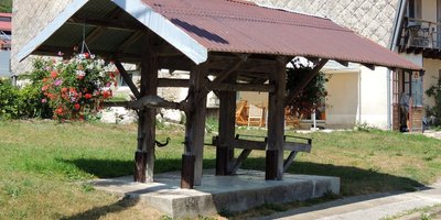
Travail à ferrer - F. Jeanparis History & HeritageCattle crush
This small wooden structure and its equipment - which is still complete in Remoray - along with the yoke which only seems to be missing some straps is also called a “cattle squeeze”. It served to immobilise large animals, horses and cattle, to work on their hooves. The construction needed to be very sturdy to withstand the animal’s strength as they were not always cooperative and to ensure the blacksmith’s safety.
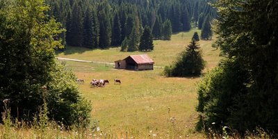
Des arbres dans les pâturages - F. Jeanparis Pastoralism and agricultureTrees in pastures
A specific High-Jura landscape and considered paradise for mushroom pickers, wooded meadows are unique places where man has reconciled grass and trees, pastures and forests.
Here, cattle can find shade, coolness and protection from the rain under the scattered trees. But beware of lightening!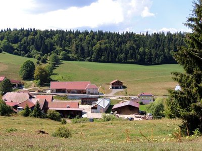
La scierie de Boujeons - F. Jeanparis History & HeritageBoujeons sawmill
Initially, the sawmill was a grain mill which used the driving power provided by the waters of the Drésine river. A sawmill then settled here in 1840 to make use of the mill’s facilities. Technical and social developments left their mark on the Boujeons sawmill and are explained and illustrated in detail by an interpretive signpost found here.
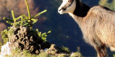
Vie de chamois - F. Jeanparis FaunaLife of a chamois
This animal lives mainly by day, in smaller or larger herds depending on the season (there tend to be more of them in the winter than in summer). Mating season is between the end of October and the end of January, during which period males are very aggressive, challenging each other with their horns and sometimes resulting in deadly falls depending on where the fight takes place. After a gestation period of around 23 weeks, females birth one or two kids, who will stay by their side until they are one year old.
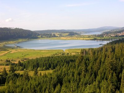
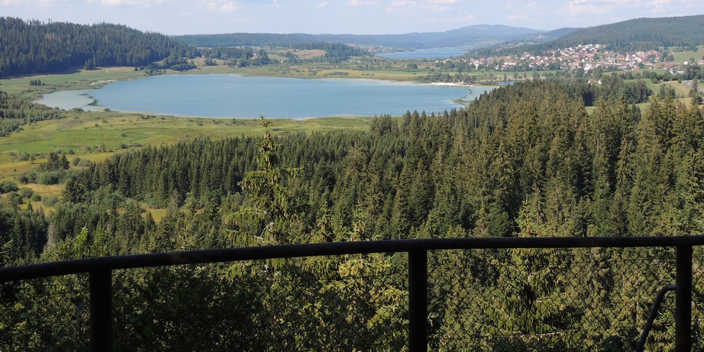
Belvédère des 2 Lacs - Gilles Prost - PNRHJ ViewpointBelvedere of the two lakes
In the foreground of this belvedere is the Lake of Remoray and its crown of peat bogs, classed as a National Natural Reserve since 1980; in the background, the Lake of Saint-Point, one of the largest natural lakes in France. A true sanctuary for biodiversity, the Reserve of the Lake of Remoray is home to a remarkable range of fauna and flora, particularly in relation to its humid environments: Common snipe, water rail, fringed pink, bird’s-eye primrose, violet copper, dark whiteface, etc. However, be careful, access to the heart of the Reserve is prohibited; this remarkable natural heritage can also be discovered at the Reserve House in Labergement-Sainte-Marie.
Learn more about the National Natural Reserve of the Lake of Remoray: http://www.maisondelareserve.fr
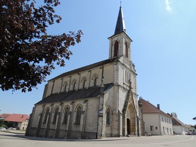
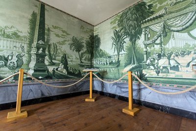
Église et ancien presbytère - F. Jeanparis History & HeritageChurch and former rectory
The Remoray church was built in a uniform neo-gothic style during the 19th century.
Nearby, the old rectory was rehabilitated as a Maison du Patrimoine (House of Heritage) in 2015 and was awarded the “Park values” label as a site to be visited. The rooms and gardens have been reconstructed as they would have been during the 19th century. The region’s history, tradition and local dialects are some of the topics addressed during visits. This place also contains a unique feature worldwide: panoramic wallpaper in the formal bedroom! (www.patrimoine-remoray.fr).
Description
From the centre of REMORAY, 

 ) take the “route des Grandes Plaines” to your right (red MTB waymarking no. 12), which gradually ascends to a forest massif towards La Côte.
Take a small muddy trail to the left, and join up with a forest path, continuing again to the left for around 900 m. In the wide bend to the right, turn left (MTB crossing) and exit onto a pasture. Follow the path to your left and then the white path that leads to Sur la Côte.
Head up the earthy path to the right, through the pastures, towards la Grande Combe.
Branch off to the left on a white path that heads into the forest and, after around 600 metres, turn right onto a grassy trail.
From here, follow a succession of small muddy, grassy or stony trails that soon meet up with a forest road.
Head down the road to your left, head past the Les Trois Portes chalet and branch off to the right to follow a path along the forest for around 1 km.
Branch off to the left again and follow the forest path that meets up with a forest road after 450 m. Follow this road to the left for 150 m and take the path to the right.
Joining up with a wide forest path just before descending to the village of Boujeons, do not miss the trail that turns left straight away (MTB path) and crosses through the pastures until coming to the village of Boujeons.
Cross the pasture by turning left, then take the forest trail that opens onto a white path. Shortly after, turn left (MTB path) and cross the pastures using a small grassy trail until you come to Les Brétilles, just above Le Brey.
Take the road to the left, without heading all the way down to the main road, and then follow a stony path that ascends into the forest through a clearing.
Branch off to the right on a forest track that heads up to the BELVEDERE OF THE TWO LAKES (BELVEDERE DES DEUX LACS).
Head down a small muddy trail to a road, then turn right to reach theRF Marcel Goux Parking lot. Head left to the Buclet intersection
on the road towards Remoray.
Follow the road to your left for 100 m and take the parallel forest path that once again comes out onto this road. Head up to REMORAY after crossing the bridge over the Drésine, a small river that feeds the Remoray lake.
- Departure : Remoray
- Arrival : Remoray
- Towns crossed : Remoray-Boujeons, Labergement-Sainte-Marie, Mignovillard, and Brey-Et-Maison-Du-Bois
Forecast
Altimetric profile
Sensitive areas
Western capercaillie
- Impacted practices:
- , Land-based
- Sensitivity periods:
- JanFebMarAprMayJunDec
- Contact:
- Impacted practices:
- Aquatic,
- Sensitivity periods:
- JanFebMarAprMayJunJulAugSepOctNovDec
- Contact:
- Parc naturel régional du Haut-Jura
29 Le Village
39310 Lajoux
03 84 34 12 30
www.parc-haut-jura.fr/
- Impacted practices:
- Land-based
- Sensitivity periods:
- JanFebMarAprMayJunDec
- Contact:
Parc naturel régional du Haut-Jura
29 Le Village
39310 Lajoux
03 84 34 12 30
www.parc-haut-jura.fr/
- Impacted practices:
- Aquatic,
- Sensitivity periods:
- JanFebMarAprMayJunJulAugSepOctNovDec
- Contact:
- DREAL Bourgogne-Franche-Comté
Cité administrative VIOTTE
5 voie Gisèle Halimi - BP 31269
25005 BESANÇON CEDEX
Tél : 03 39 59 62 00
Recommandations
For an MTB outing, wear a helmet and bring enough water. Paths are shared with pedestrians and horse riders, who have priority, therefore, please adapt and control your speed.
During humid weather, most trails on this circuit may be muddy and slippery.
You will need to cross MTB paths, do not hesitate to get down from your bike.
This trail passes through pastures and forest paths. To respect the owners granting you passage, and for the security of livestock and wild fauna, we ask that you remain on the waymarked paths and close gates behind you.
Wild flowers are beautiful, they may be rare and protected and often wilt quickly. Do not pick them! They will delight the next admirers.
In case of forest works (felling, skidding, etc.), for your safety, know when to stop and turn around.
Information desks

Tourist information centre - Métabief
6 place Xavier Authier, F-25370 Métabief
Tourist information centre - Pontarlier
14 bis rue de la Gare, F-25300 Pontarlier
Transport
To visit and get about in the High-Jura, visit www.reshaut-jura.fr, the eco-mobility portal listing all means of transport within the Park.
Access and parking
Parking :
More information
Report a problem or an error
If you have found an error on this page or if you have noticed any problems during your hike, please report them to us here:
Close by2
Laid-out site
Belvedere of the Two Lakes
A short and shaded ascent will lead you to this adapted belvedere, with breath-taking views over the Remoray lake natural reserve.
A strategic place to observe the landscape: the composition of natural elements, man’s adjustment to this environment, etc., or to simply bask in its sights and sounds.