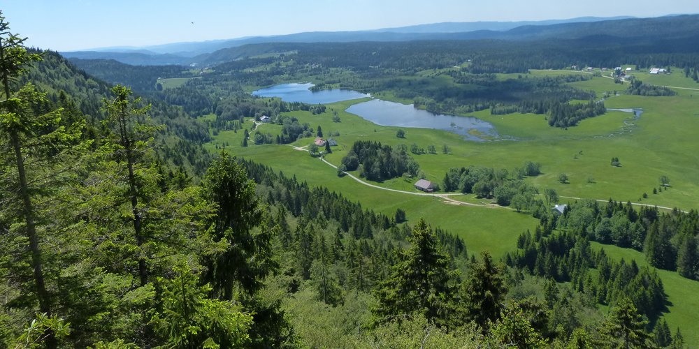
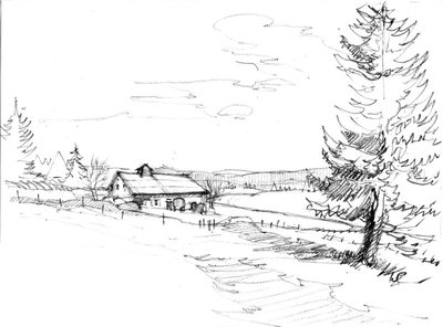
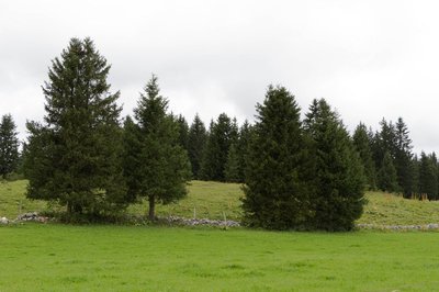
The Mortes and Bellefontaine Lakes
"20,000 years ago, the glacier would crash against the Roche Champion cliff, before giving way to a lake. Later, climate change would foster an abundant amount of aquatic vegetation, the slow decay of which filled the depressions of the black peat."
Marc Forestier, (Dakota Edition, Que faire dans le Parc naturel régional du Haut-Jura - What to do in the natural regional park of the High-Jura)
20 points of interest
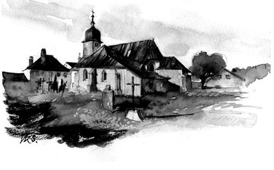
Eglise Saint Jean-Baptiste - History & HeritageSaint-Jean-Baptiste Church
Works to build the church started in 1634. The massive appearance of this structure is amplified by the narrowness of its openings. It is covered with a metal shingle on its most-exposed outer walls. The church has been registered on the complementary inventory of Historical Monuments since 2 March 1981.
- Nina Verjus - PNRHJ Natural environmentsFirst appearance of the landscape
100 to 200 million years ago, we would have travelled here by boat, on a tropical sea. Then limestone particles and shells slowly started to gather on the waterbed, gradually forming limestone layers.
During the Tertiary Period, these layers started to lift, fold and soon gave birth to the Jura Massif, with its relief comprised of folds and plateaux.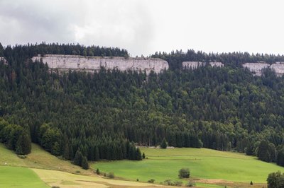
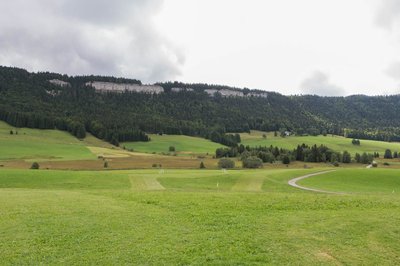
Roche Champion - Nina Verjus - PNRHJ History & HeritagePlaces full of history
Opposite you, the Roche Champion cliff marks the edge of the Risoux massif and separates Switzerland from France.
Before the 16th century, neither of these two countries wanted to claim the Jura, which was covered in forest. However, as the area was progressively cleared for agricultural purposes, competition for this land stepped up a notch. The Reform later exacerbated this rivalry, creating a political and religious rift between Switzerland and Protestants on one side and Franche-Comté and Catholics on the other. The Catholic cross that can be seen atop Roche Champion asserts this religious belonging.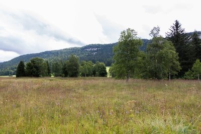
Tourbière - Nina Verjus - PNRHJ GeologyAppearance of the peat bog landscape
At the end of the Quaternary Period, the Jura was covered by a huge glacier. Reindeer and mammoths were abundant. This mass of ice changed the relief and broke and moved rocks. When it melted, the ice left glacier moraines in the watertight rocky holes left behind.
At the bottom of the depression, a lake later took shape, fed by the water from the melting glacier, from rainfall and from streams. Before long, the climate started to warm up. Aquatic plants quickly developed and organic matter accumulated. The lake filled and turned into a marsh.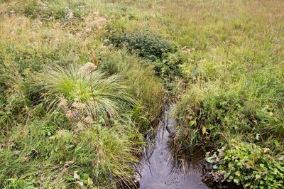
Des ruisseaux qui serpentent dans la tourbière - Nina Verjus - PNRHJ Lakes & RiversStreams snaking through the peat bog
The stream you have crossed comes from the Cives combe. It is joined by another stream from the Risoux slopes (the mountain looming over you). After travelling underground, the stream surfaces near Morez, around ten kilometres from here. From there to here, it passes through the peat bog, with the latter acting like a sponge during rainy weather and when snow starts to melt. By doing so, the peat bog limits flooding, and then gradually returns the water during dry periods. Its last function is to purify the water running through it by acting as a filter.
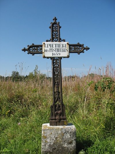
Cimetière des pestiférés - History & HeritageThe plague cemetery
In 1639, the plague wreaked havoc in the region. In Chapelle-des-Bois, it killed roughly fifteen of the 150 village inhabitants. Fearing that they might catch the illness, survivors did not want to bury the dead in the cemetery. Their decision to bury the plague-ridden corpses in the peat bog is no accident. Considered worthless land, and rarely used for agricultural purposes, the peat bog seemed the ideal place to bury victims of the plague without contaminating the land.
Tourbière - Nina Verjus - PNRHJ GeologyFormation of the peat bog
Sedges (or carex) grow and help stabilise the soil. Later, sphagnum peat moss takes over and forms a dense carpet. These are species of moss that grow continuously and that provide an accumulation of organic matter on which sphagnum peat moss is able to grow. The vegetation becomes compact and creates the black and fibrous bogs resembling garden compost. However, this phenomenon is painfully slow and it takes thousands of years for a peat bog to reach a height of just a few metres.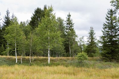
Tourbière - Nina Verjus - PNRHJ GeologyPeat bogs: history books
Peat bogs are valuable history books for pollen specialists or palynologists. In fact, pollen is well-preserved in peat bogs, and some pollen found there can even be thousands of years old!
From the oldest layers deeper down to the surface area, palynologists are able to retrace the history of plants in the peat bog and its surroundings all the way back to prehistoric times. Which trees used to grow in the forest? Which plants did man grow for food or for clothes? By analysing pollen, we can learn all of these things.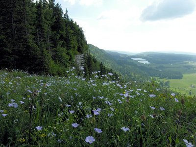
Roche Champion - ViewpointViewpoint from Roche Champion
From the top of the rocky bar overlooking the Chapelle-des-Bois valley and its village, your eyes will view a wide landscape, from the combe of Cives to the north, to the two almost twin lakes that are the Lac des Mortes and the Lac de Bellefontaine to the north. The hydraulic regime of both lakes is quite particular: during high waters, the Lac de Bellefontaine’s waters overflow into the Lac des Mortes; however, during low waters, the water in the Lac des Mortes feeds the Lac de Bellefontaine.
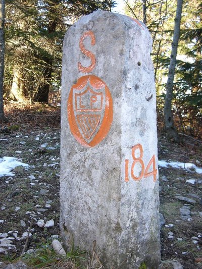
Borne - History & HeritageEmpires and landmarks
The tracing of the borders, following the Paris Treaty of 1815 was symbolised by landmarks linked together with a low dry wall. However, the border has not always been watertight, and it symbolises what has come to be a lifestyle. More than a border, the Franco-Swiss frontier, which runs along the Risoux ridge line, is a place of passage and of exchanges, both lawful and unlawful, over time.
Git de l'échelle - History & HeritageThe Gît de l’échelle and its viewpoint
“Gîts”, steep trails where the wood exploited on the Risoux used to be discarded, also served as a passageway to Switzerland. These Gîts were given a name, and some have an entire history; the Gît de l’Echelle, the Gît d’Entre-Deux-Roches... During the 19th century, smuggling activities enabled some to live entirely off the unlawful trading of consumer goods that could be found at a lesser cost on one side or the other of the border.
The Gît de l’Echelle, despite its steepness, served in particular as a passage for resistance fighters and intelligence officers and saved Jewish families during the Second World War thanks to the temerity and bravery of local smugglers, both French and Swiss.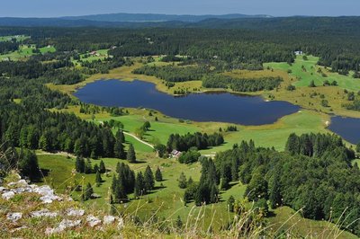
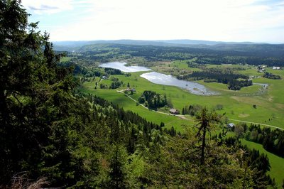
Roche Bernard - ViewpointViewpoint from Roche Bernard
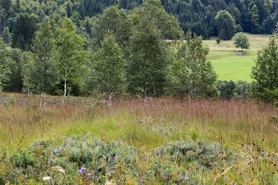
Like other Jura peat bogs, those of the Les Mortes and Bellefontaine lakes are a testament to the glacier that covered the Jura twenty thousand years ago and that left in its wake impervious moraines. These impervious depressions filled with stagnant water and were populated by plants. On the soft soil of the peat bogs grow some plants that are particularly suited to this environment (Cranberry, bog-rosemary, cotton grass, Drosera, etc.).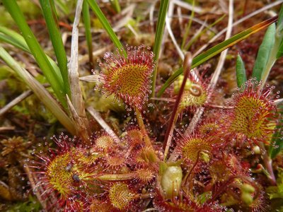
Drosera - Pierre Durlet - PNRHJ FloraThe round-leaved sundew
This small carnivorous plant has hairs covered with a type of glue. When an insect comes into contact with the plant, it finds itself stuck and cannot escape. The leaf trap then slowly closes-in on its prey, and secretes digestive juices that digest the insect. This adaptation allows the plant to acquire supplementary intake in this environment in which roots struggle to find enough food. It is also called common sundew, due to its appearance.
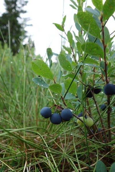
Airelle des marais - Pierre Durlet - PNRHJ FloraThe bog bilberry and the moorland clouded yellow
From the blueberry family, it grows in “raised” peat bogs and is slightly acidic. Its berries are not as sweet as blueberries. It is the plant that is host to the moorland clouded yellow, a beautiful yellow butterfly which, when in caterpillar form feeds on the bog bilberry.
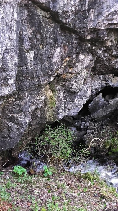
La perte du lac - Gilles Prost - PNRHJ Lakes & RiversThe disappearance of the lake
The waters of the Les Mortes lake form a short stream barely one kilometre-long before disappearing into (or dying in) a crevice at the heart of the “Les Mortes” hamlet. These waters are drawn just under ten kilometres downstream from the Arce source in Morez and serve to provide part of this High-Jura town’s population with drinkable water.
La Chaumoz - History & HeritageLa Chaumeau or Chaumeau, a farm with a “tué”
This house’s roof is pierced through the top by a “Tué”, a wooden pyramid-shaped chimney measuring at its base about 3 metres wide and at its summit around 1 metre wide. The Tué, which is positioned near the centre of the house, is a room caught in a draught, where all of the smoke gathers, and serves as a pantry, ensuring that sliced meat in particular is well preserved.
To learn more: The Michaud farm ecomuseum in the Combe des Cives (Chapelle-des-Bois) http://ecomusee-jura.fr/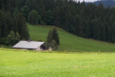
Un habitat dispersé dans le paysage - Nina Verjus - PNRHJ History & HeritageA dispersed-habitat landscape
You have now exited the wooded meadow and have come across vast stretches of wild land. Wild? Well, not really. If you look closely, Man has left his mark on this landscape.
Farms are scattered here and there and tell the story of how the High Doubs was “colonised’. In this area, where winters are long, home-based craftmanship, wood carving or clock-making developed to keep the peasants busy when the cold season forced them to stay inside.
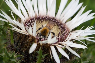
Mille couleurs dans les prairies naturelles - Nina Verjus - PNRHJ FloraA thousand colours in natural prairies
The vast landscapes you are in are natural prairies, in which biodiversity is particularly abundant and contributes towards the production of PDO (Protected Designation of Origin) cheeses. Farmers in Chapelle-des-Bois and the surroundings are particularly aware of this and ensure that the unicity of these landscapes is preserved by using suitable practices.
L'architecture du Haut-Doubs - Nina Verjus - PNRHJ History & HeritageArchitecture of the High-Doubs
In the hamlet of “les Landry”, you will pass in front of a house that tells of some of the architectural history and construction techniques used in the High-Doubs. Years of “playing around” with wood, stone and metal.
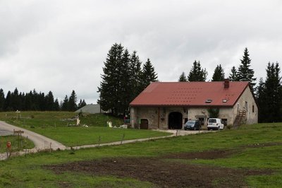
Une agriculture qui marque le paysage - Nina Verjus - PNRHJ Pastoralism and agricultureFarming activities that leave their mark on the landscape
Agricultural buildings are scattered throughout this landscape: old farms are found alongside much larger modern agricultural buildings that house Montbeliarde cows. These cows produce the milk that is used to produce local cheeses.
Description
From the village's small central square, at the hike's starting point, the trail follows the D 46 towards the town hall (white and red waymarking). At "chemin des Sources", a road to the left crosses the combe, borders a peat bog and ascends to La Madone.
The path skews off to the left crossing a wooded meadow. At the Reservoir, the trail ascends to the right through a pasture and leads to LA ROCHE CHAMPION. Occasionally rocky, this path continues between the rocky barrier and the swiss border, heads past the Git de l’Echelle and on a wider path, leads to Sur-le-Risoux-des-Lacs, and, turning right, to the Rocky Crossroads.
The unmissable belvedere of Roche Bernard can be accessed to the left within 5 mins.
From the Rocky Crossroads, a stony forest road, "heads down the hill" (yellow and red waymarking) before leading to the Customs Barrack.
Follow the road to the left (white and red waymarking). Head past the ON THE LAKES viewpoint and continue on a white path that overlooks the peat bogs through La Feuillat until you reach les Grands Pins.
The trail then follows the D 18 to the right (yellow waymarking) and at the first crossing (the Chalet of Mandrillons) takes a left turn onto the road towards Chaux Mourant before reaching les Assignats.
To the right a forest path interspersed with clearings leads to the Chez Bourgeois and Chez Jean Bouveret hamlets. Continuing in the same direction, the trail which is mostly a forest path opens onto the D18 at LES MORTES. Follow the road to the left and take the little road to the les Mortes hamlet (yellow and blue waymarking) to reach Les Mortes Little Woods Crossroads to the left via the D46.
The trail takes the D 46 E to the left and leads a crossroads with "chemin des Bornes". A path heads uphill to the right, enters the forest and descends to La Toumire and later La Chaumeau.
The path the heads back uphill to the right along the edge of the la Chaumeau pasture, branches off to the left along a trail through the meadows towards to the road to les Chaumelles.
Cross the road and, on the other side, a combe and a wooded meadow that lead to les Champs Nouveaux.
Take the road to LES LANDRY to your right (white and red waymarking), and then a road west of the village to return to CHAPELLE-DES-BOIS.
- Departure : Church parking lot, Chapelle-des-Bois
- Arrival : Church parking lot, Chapelle-des-Bois
- Towns crossed : Chapelle-Des-Bois and Bellefontaine
Forecast
Altimetric profile
Sensitive areas
Western capercaillie
- Impacted practices:
- , Land-based
- Sensitivity periods:
- JanFebMarAprMayJunDec
- Contact:
- Impacted practices:
- Aquatic,
- Sensitivity periods:
- JanFebMarAprMayJunJulAugSepOctNovDec
- Contact:
- Parc naturel régional du Haut-Jura
29 Le Village
39310 Lajoux
03 84 34 12 30
www.parc-haut-jura.fr/
Recommandations
Be careful on the steep slopes and cliff edges between Roche Champion and Git de l’Echelle.
This trail passes through pastures with livestock and forest paths. To respect the owners and farmers granting you passage, and for the security of livestock and wild fauna, we ask that you remain on the waymarked paths.
Use the adapted passageways to get across fencing and be sure to close gateways behind you. Please keep your dog on a lead if you have one.
Wild flowers are beautiful, they may be rare and protected and often wilt quickly. Do not pick them! They will delight the next hikers.
In case of forest works (felling, skidding, etc.), for your safety, know when to stop and turn around.
Information desks

Tourist information centre - Val de Mouthe
3 bis rue de la Varée, 25240 Mouthe
Transport
To visit and get about in the High-Jura, visit www.reshaut-jura.fr, the eco-mobility portal listing all means of transport within the Park.
Access and parking
16 km south of Mouthe via the D 437 followed by the D 46, and 15 km from Morez via the N 5, followed by the D 18 through Bellefontaine and lastly the D 46.
Parking :
Report a problem or an error
If you have found an error on this page or if you have noticed any problems during your hike, please report them to us here: