The two lakes belvedere
6 points of interest
Au fil de l'eau - Lakes & RiversAlong the water
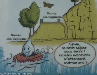
Scattered with terminals and fun games, this interpretive trail invites you on a discovery on the secrets of the water cycle (infiltration, evaporation, recovery, etc.) in a limestone massif such as the Jura massif.

Cingle Plongeur - Fabrice Croset FaunaThe Dipper
With its nest hidden from view, this water bird feeds on larvae, insects, molluscs and small fish... by walking under water. In March or April, 4 to 6 eggs are placed by the female in a dome-shaped nest made up of moss, dry grass and leaves. After 14 to 16 days incubation by the female, both parents busy themselves for around one month with feeding their chicks, after which they will take flight.
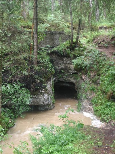
Source des capucins en crue - PM. Aubertel Lakes & RiversThe Source of les Capucins
“At the beginning of the century, the municipality of Frasne ordered works to develop the gallery in order to harvest the water (Fournier). There are still traces of such development with the dry-stone walls.
This is a lasting emergence with a siphon 15 metres from the entrance. The siphon is partially obstructed by the earthworks for the road that passes just overhead.
The flooded gallery was recognised on 16 June 1974 by the Groupe Lémanique de Plongée Souterraine over 43 m, less than 10 m deep. This source is still harvested, and the waters run clear, even at average water levels." (Fournier E. Spelunca 5e campagne 1902-1903 p 27 SHAG 1977 Enfonçure no 3 p 26 GLPS 1976 Info-Plongée no 1)
Truite lacustre - Fédération de pêche du Jura FaunaRiparian trout
This is a natural adaptation of common river trout. Adults spend the warmer period of the year when streams lack water in the coolness of lakes. In the autumn, the return to the streams to lay their eggs. Eggs hatch at the end of the winter.
The riparian Trout population in the lakes of Saint-Point and Remoray have sharply declined since the 70s/80s. The quality of water in the lakes as well as the physical qualities of streams in which they would reproduce has now largely deteriorated.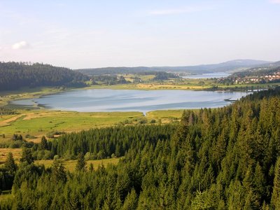
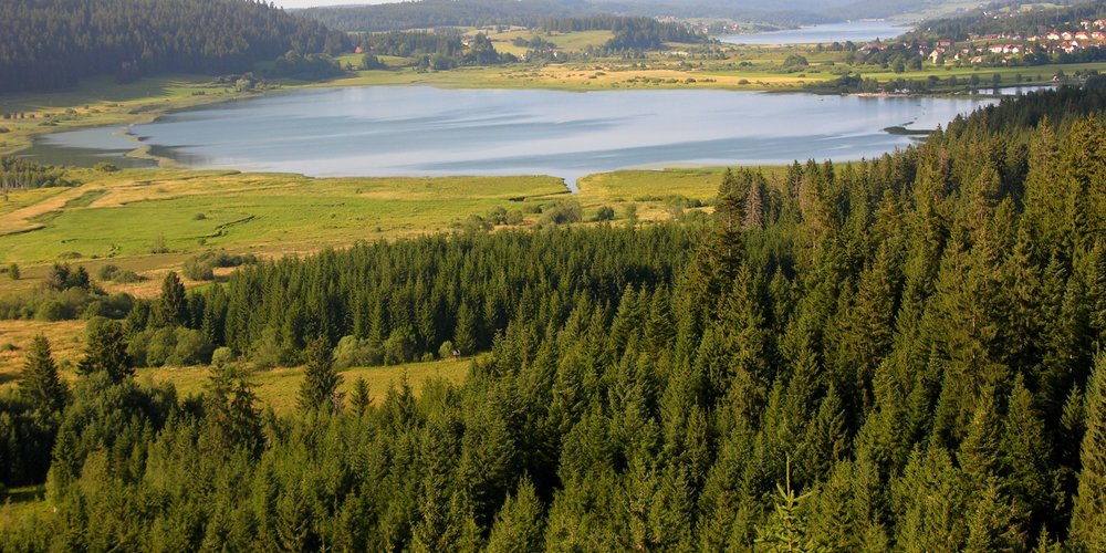
Belvédère des 2 Lacs - Gilles Prost - PNRHJ ViewpointBelvedere of the two lakes
In the foreground of this belvedere is the Lake of Remoray and its crown of peat bogs, classed as a National Natural Reserve since 1980; in the background, the Lake of Saint-Point, one of the largest natural lakes in France. A true sanctuary for biodiversity, the Reserve of the Lake of Remoray is home to a remarkable range of fauna and flora, particularly in relation to its humid environments: Common snipe, water rail, fringed pink, bird’s-eye primrose, violet copper, dark whiteface, etc. However, be careful, access to the heart of the Reserve is prohibited; this remarkable natural heritage can also be discovered at the Reserve House in Labergement-Sainte-Marie.
Learn more about the National Natural Reserve of the Lake of Remoray: http://www.maisondelareserve.fr
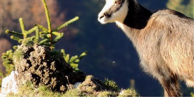
Vie de chamois - F. Jeanparis FaunaLife of a chamois
This animal lives mainly by day, in smaller or larger herds depending on the season (there tend to be more of them in the winter than in summer). Mating season is between the end of October and the end of January, during which period males are very aggressive, challenging each other with their horns and sometimes resulting in deadly falls depending on where the fight takes place. After a gestation period of around 23 weeks, females birth one or two kids, who will stay by their side until they are one year old.
Description
Starting in the BREY town hall parking lot, the trail (yellow and blue waymarking) heads down the village via the road just below the main road, before leaving the hamlet by passing alongside the D 437.
The path - which is suitable for vehicles - heads towards le Fuverat and passes through the artisanal zone, before leading to a new fork. The trail continues on a forest road that descends to the left. After crossing the « Lhaut » stream, the itinerary meets up with a road, in this open forest, that you will follow to the left. Walk past the Capucins source to reach the Lhaut bridge. The trail then heads back uphill for around 10 meters along the D437 (Take care when crossing the road!).
At the junction with a forest road, climb the embankment and take the trail that gradually ascends through the forest, to access "route de Remoray", in Buclet.
To the left the circuit joins the RF Marcel Goux parking lot to access the forest road and follows this road 100m uphill before taking a steep trail opening on to the TWO LAKES BELVEDERE.
With your back to the belvedere, a trail runs through the forest, crosses a pasture, before coming to a road just under the Brey hamlet. This trail then ascends to the right towards les Bretilles.
Return to your starting point by heading down the farm road with low walls and ash trees to your left (take care when crossing the D437).
- Departure : Le Brey
- Arrival : Le Brey
- Towns crossed : Brey-Et-Maison-Du-Bois and Labergement-Sainte-Marie
Forecast
Sensitive areas
- Impacted practices:
- Aquatic,
- Sensitivity periods:
- JanFebMarAprMayJunJulAugSepOctNovDec
- Contact:
- Parc naturel régional du Haut-Jura
29 Le Village
39310 Lajoux
03 84 34 12 30
www.parc-haut-jura.fr/
- Impacted practices:
- Aquatic,
- Sensitivity periods:
- JanFebMarAprMayJunJulAugSepOctNovDec
- Contact:
- DREAL Bourgogne-Franche-Comté
Cité administrative VIOTTE
5 voie Gisèle Halimi - BP 31269
25005 BESANÇON CEDEX
Tél : 03 39 59 62 00
Recommandations
This trail passes through pastures with livestock and forest paths. To respect the owners and farmers granting you passage, and for the security of livestock and wild fauna, we ask that you remain on the waymarked paths. Use the adapted passageways to get across fencing and be sure to close gateways behind you. Lastly, please keep your dog on a lead if you have one.
Wild flowers are beautiful, they may be rare and protected and often wilt quickly. Do not pick them! They will delight the next hikers.
In case of forest works (felling, skidding, etc.), for your safety, know when to stop and turn around.
Information desks

Tourist information centre - Val de Mouthe
3 bis rue de la Varée, 25240 Mouthe
Transport
To visit and get about in the High-Jura, visit www.reshaut-jura.fr, the eco-mobility portal listing all means of transport within the Park.
Access and parking
Parking :
Report a problem or an error
If you have found an error on this page or if you have noticed any problems during your hike, please report them to us here:
Close by1
Laid-out site
Belvedere of the Two Lakes
A short and shaded ascent will lead you to this adapted belvedere, with breath-taking views over the Remoray lake natural reserve.
A strategic place to observe the landscape: the composition of natural elements, man’s adjustment to this environment, etc., or to simply bask in its sights and sounds.