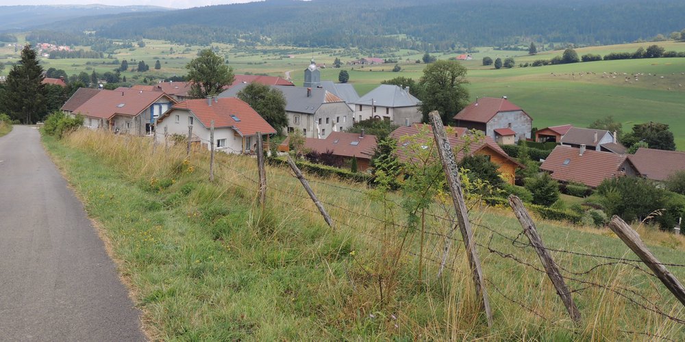
The Rivier
In the country of Comté and Mont d’Or, the pastures ring with the bells that are proudly worn by the Montbeliarde cows. A few breaks are naturally necessary to benefit from the view offered over the wide valley of the Doubs just downstream from Mouthe.
4 points of interest
%20PNRHJ%20-%20F.%20Jeanparis.jpg.400x0_q85.jpg)
Citerne d'alpage - F. Jeanparis History & HeritageAlpine pasture cisterns
Far from the rivers, and particularly in alpine pastures, when the permeability of the soil hinders water storage, inhabitants were required to create structures to hold water. Here, the roof collects and stores rain and snow water. When full, the cistern was capable of providing several months of autonomy to maintain the livestock.
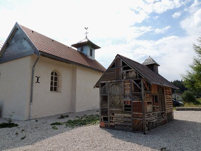
La chapelle Sainte-Barbe et sa petite soeur - F. Jeanparis History & HeritageSainte-Barbe chapel and its little sister
Built during the 16th century and dedicated to Sainte-Barbe, the Maison-du-Bois chapel was a place of prayer and pilgrimage up until the First World War. In 1941, with the return of the Prisoners held in Germany, the parish priest returned it to its original purpose by transferring the bell from the Saint-Sébastien du Brey church, dated 1663.
Note the presence of the monumental cross decorated with two Saints, attached to the chapel. Renovated in 2013, they originally date back to the 15th century. Next to the chapel, like a twin, an insect hotel made out of wood and brick is home to a multitude of life of all kinds.%20PNRHJ%20-%20F.%20Jeanparis.jpg.400x0_q85.jpg)
Vue sur le Mont d'Or - F. Jeanparis ViewpointViewpoint over Mont d’Or
From the heights of Maison-du-Bois, the view is open: the ridges that are visible are those of the Mont d’Or, where alpine pastures cover the summits and feed the herds of heifers in the summer. During clear weather, a jagged silhouette can be seen in the distance: these are the aiguilles de Baulmes, reaching 1,559 metres of altitude in our Swiss neighbour’s territory.
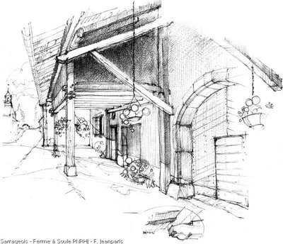
Ferme à Soule - F. Jeanparis History & HeritageSarrageois, a linear settlement
Along a main roadway, these adjoining houses form a “building front”. The main facade of these dwellings faces the public road. Here, you may observe different sized openings depending on the use of the building: stables, barns and houses.
At the back of these houses, the private gardens often overlook the meadows.
The roof overhang is supported by gabled walls and is often complemented by a gallery for drying wood, peat and crops.
Description
From SARRAGEOIS, take chemin de Capiche (Green MTB waymark no. 99), a small road that ascends through pastures to the crossroads in La Capiche.
Continue on this road, and enter the wood of la Pila, until you come to the Combe of Ashes.
Branch off to the right on the road through the middle of pastures, towards Gros Buisson, and then Les Paris, before finally descending to MAISON DU BOIS.
Take the road to the right just before the large village farm and follow a white path that ascends through the pastures to an MTB path. The grassy trail cuts through a pasture and continues on a trail through the undergrowth, before reaching le Lasenois.
Turn left and follow the road down towards SARRAGEOIS and your starting point.
- Departure : Sarrageois
- Arrival : Sarrageois
- Towns crossed : Sarrageois, Rondefontaine, Remoray-Boujeons, Brey-Et-Maison-Du-Bois, and Gellin
Forecast
Recommandations
For an MTB outing, wear a helmet and bring enough water.
Paths are shared with pedestrians and horse riders, who have priority, therefore, please adapt and control your speed.
This trail passes through pastures and forest paths. To respect the owners granting you passage, and for the security of livestock and wild fauna, we ask that you remain on the waymarked paths. You will need to cross MTB paths, do not hesitate to get down from your bike.
.
Wild flowers are beautiful, they may be rare and protected and often wilt quickly. Do not pick them! They will delight the next admirers.
In case of forest works (felling, skidding, etc.), for your safety, know when to stop and turn around.
Information desks

Tourist information centre - Val de Mouthe
3 bis rue de la Varée, 25240 Mouthe
Transport
To visit and get about in the High-Jura, visit www.reshaut-jura.fr, the eco-mobility portal listing all means of transport within the Park.
Access and parking
2.5 km from Mouthe via the D437 towards Pontarlier.
Parking :
More information
Report a problem or an error
If you have found an error on this page or if you have noticed any problems during your hike, please report them to us here: