The Rocks of Orvaz
A hike along ledges through the undergrowth or through vast pastures, where greenery is omnipresent, with a thousand different tones from the raw green of the pastures to the dark and bluish green of the fir trees. A natural patchwork will unfold before your eyes!
5 points of interest

Chalet de fromagerie de Belleydoux - Roman Charpentier History & HeritageThe Belleydoux cheese dairy chalet
Built in 1908, this impressive and unique building was paid for with funds from the sale of municipal woods. At the time, the municipality justified the cost of works by “[...] the urgent need to provide farmers with a chalet equipped with the latest improvements in the cheese dairy industry to ensure profitable returns for milk producers”. Between 1930 and 1940, it gathered over forty members. The production of gruyere cheese required that a significant number of producers come together. This chalet was certainly built at the expense of much smaller cheese dairies, which were not as easily accessed and not as well equipped.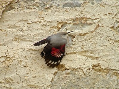
Le Tichodrome échelette - Fabrice Croset FaunaThe wallcreeper
A high-mountain bird during the summer, the wallcreeper heads for the Jura between autumn and spring. Roughly the size of a sparrow, you will have the most chance of seeing it on the cliffs. A tireless surveyor, it creeps along cliff walls in search of small insects or spiders in the cracks. You will recognise it by its bright red wings.
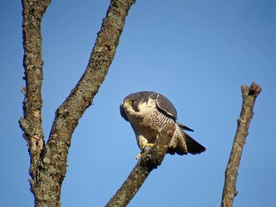
Le Faucon pèlerin - Fabrice Croset FaunaThe Peregrine Falcon
Loops, dizzying dives, chases: between February and March, during mating season, these birds pair up and put on spectacular shows in the sky. This bird of prey can reach speeds of up to 350 km/h when in a vertical dive. Its quickness means that it is able to catch other birds mid-flight to feed. This ability has been used by falconers as a hunting weapon.
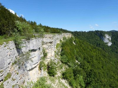
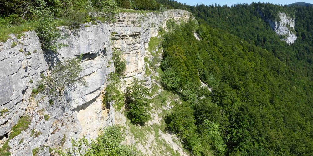
Les Roches d'Orvaz - Gilles Prost - PNRHJ Natural environmentsThe Rocks of Orvaz
This long and friable limestone cliff shows signs of erosion; faults spread from under your feet. (Take care when walking along the cliff and remain on the trail). The Rocks of Orvaz overlook the hamlet and the combe of Orvaz. Opposite the Roche Fauconnière (Falcon Rock), named after its resemblance to a falcon with wings outstretched, overlooks the Semine valley.
Poussin Gélinotte des bois - Julien Barlet - PNRHJ FaunaThe Hazel Grouse, a very discreet bird
Barely bigger than a dwarf hen, the Hazel Grouse’s silhouette is rather large, with short legs and a short tail. Its plumage is subtly shaded and enables it to camouflage itself in its environment. In spring, it feeds on the buds of hazel trees or other shrubs covering the forest floor. Very discreet, you may hear it quickly fly away on your arrival. Be careful, as from June, a subject that does not fly away may be looking to protect its young. Discreetly move away.
Description
From the BELLEYDOUX CHALET, the trail descends via a road to the left (yellow waymarking) towards the church Head around the church and along a first cemetery before walking under a second. Head down a farm path and cross over the Chon (stream) before heading up a meadow. Find a little road that leads to the entrance to the hamlet of GOBET.
The road ascends to the right (drinking trough, vaulted cistern) into the hamlet and then branches off to the left (ignoring the road to the right towards Châtelet). You will come to a hairpin in the road.
Continue on a farm path (hedges) until you reach a stony path. Continue to the left and head up into the forest until you reach la Croix. The road continues to the left and comes to a cistern at le Bugnon.
Branch off to the right (earthy path) to reach the CHEMIN DU FACTEUR.
> You can access the ROCKS OF ORVAZ by following the trail to the left, within 30 minutes there and back.
On returning to the CHEMIN DU FACTEUR, descend through the meadows toward Orvaz to the south. On the verge of a pretty beech forest, turn left (the descent is steep, be careful!) to reach “chemin du Soufflet”. From here, branch off to the left (crossing the stream) and exit through the meadows into the hamlet of ORVAZ.
> The Semine riverside is 30 minutes away there and back on your left (not waymarked).
Follow the road to the right for 600 m until you come to a wooded square at the Pontard Bridge. Cross the bridge and ascend for a few tens of meters, then branch off to the right to follow a trail along the left embankment of the Semine until you come to the viaduct (viewpoint to the north over the tope of a gendarme and its limestone folds). Cross the viaduct to your right.
Take the road below the D 48 to your left. Head past two houses. The path slowly ascends to Bas Belleydoux. Follow the road to your left and head past a bend. Take a trail to your right that cuts across a bend in the road. Follow the road to the right, and head opposite a crossing, towards the village, that you will reach by ascending through meadows.
- Departure : Belleydoux
- Arrival : Belleydoux
- Towns crossed : Belleydoux
Forecast
Altimetric profile
Recommandations
Be careful along the edge of the cliffs on the Rocks of Orvaz and on the descent along Chemin du Facteur.
This trail passes through pastures with livestock and forest paths. To respect the owners and farmers granting you passage, and for the security of livestock and wild fauna, we ask that you remain on the waymarked paths. Use the adapted passageways to get across fencing and be sure to close gateways behind you.
Please keep your dog on a lead if you have one.
Wild flowers are beautiful, they may be rare and protected and often wilt quickly. Do not pick them! They will delight the next hikers.
In case of forest works (felling, skidding, etc.), for your safety, know when to stop and turn around.
Information desks

Tourist information centre - Haut-Bugey
Espace des trois lacs - 4 rue du Docteur Mercier, 01130 Nantua
Transport
To visit and get about in the High-Jura, visit www.reshaut-jura.fr, the eco-mobility portal listing all means of transport within the Park.
Access and parking
18 km east of Oyonnax via the D 13 and 20 km south of Saint-Claude via the D 124 to reach Belleydoux. From this village, take the D 33 followed by the D 48 towards Giron until you reach the Orvaz viaduct.
Parking :
Report a problem or an error
If you have found an error on this page or if you have noticed any problems during your hike, please report them to us here: