
The Pierre-qui-Vire
In the intimacy of a rocky cirque, at the end of a shaded valley, the water falling from the Maissiat stream has steadily built, over thousands of years, an actual pyramid. A pyramid in the Jura? Yes, sir, but a pyramid of tufa.
4 points of interest
Cité de Dortan - Roman Charpentier History & HeritageCity of Dortan
In Dortan, only the castle, the church and a few houses were spared from a fire set by the German troops on 21 July 1944 after ten days of deadly occupation (35 dead in total). Most inhabitants sought refuge in the surrounding forests. Many local stories tell of the suffering that the entire village witnessed.
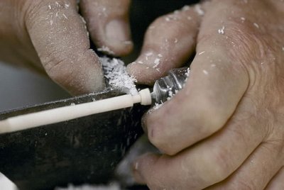
Tournerie et jeu d'échec - Benoit A La Guillaume Know-howWood-turning and chess
Inhabitants of the Jura have learnt to capitalise on boxwood, a shrub with very hard wood, by using it for wood-turning. This manufacturing technique consists of working the wood using a horizontal wood lathe. The craftsman places the piece of wood on the lathe, in front of him, and spins it very quickly, whilst sculpting the wood with a skew chisel. This technique is used in particular to make chess pieces, a game that is particularly popular in this village.
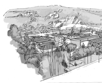
Point de vue de la Pierre-qui-Vire - Gilles Prost - PNRHJ Peak – ViewpointViewpoint from la Pierre-qui-Vire
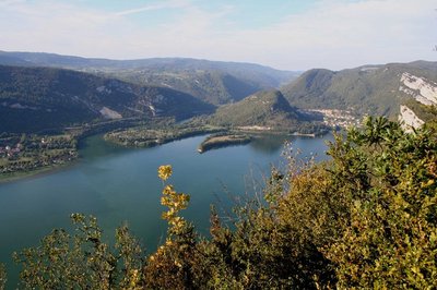
At the foot of Molard de Netru, where the Bienne meets the Ain, is the Coiselet Lake. This lake is a 10-kilometre-long artificial lake created in 1970 when a hydropower dam was built. This lake is marked on its western edge by the Pic d’Oliferne, with an altitude of 807 m and on which a castle was built in the 13th century, now mostly in ruins.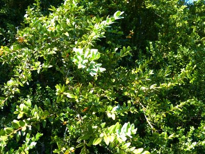
Le buis - Gilles Prost - PNRHJ FloraBoxwood
The presence of boxwood, which is easily recognisable from its small, stiff and oval leaves, is proof of an environment’s dryness. Its seed is capable of sprouting from a tiny crack, where there is almost no soil. Boxwood favours heat and humidity, like many other plants, but it can also withstand period of drought. For this purpose, it has a secret weapon: its leaves are covered with a thick and shiny skin and look as though they have been varnished. This feature limits perspiration and therefore water loss. In fact, it’s almost as though this species holds its breath during dry periods.
Description
From the DORTAN TOWN HALL square, the trail (yellow waymarking) heads right on “rue du Colonel Romans-Petit. After the Merdançon bridge, follow “rue Neuve” to the right, and then ascend “rue de l’Étang” for 30 m, before taking the path to your left. Cross “rue de la Léchère” to reach “rue Bellevue” at Maissiat Bridge. Follow the road to the right for 60 m and branch off to the left, ascending on a path that leads to les Molarets.
> The tuffaceous waterfall of the Maissiat stream is accessible within 25 mins there and back to your left, via the Combe.
The road leads to the hamlet of MAISSIAT. In the hamlet (house with flagstone gables, closed garden with standing stones, round fountain cut into a block of limestone), take the path to the right between the houses, then immediately turn left (low stone wall) onto a wide and shaded path; it ascends in stages, passes through Trechet, and serves meadows before reaching a reservoir.
The path branches off to the left, heads past a forest clearing (viewpoint over the cluse of low Bienne, between Dortan and Chancia where the mound of Nétru breaks away from the earth) and comes to Aux Combes.
The steep trail climbs up to the right to a ridge at PIERRE QUI VIRE.
> The Pierre-qui-Vire, 5 minutes there and back: be careful on the cliffs!
On returning, the trail heads to the right and winds through the forest of boxwood, heads past a ridge and then descends back down to the Tower. The path continues its descend to the left, before reaching Le Traversier Dareya.
Descend to the left to head back to Aux Combes and take the way you came to return to Dortan.
- Departure : Maissiat
- Arrival : Maissiat
- Towns crossed : Dortan
Forecast
Altimetric profile
Recommandations
Be careful along the edge of the cliffs at the Pierre-qui-Vire.
This trail passes through pastures with livestock and forest paths. To respect the owners and farmers granting you passage, and for the security of livestock and wild fauna, we ask that you remain on the waymarked paths. Use the adapted passageways to get across fencing and be sure to close gateways behind you.
Please keep your dog on a lead if you have one.
Wild flowers are beautiful, they may be rare and protected and often wilt quickly. Do not pick them! They will delight the next hikers.
In case of forest works (felling, skidding, etc.), for your safety, know when to stop and turn around.
Information desks

Tourist information centre - Haut-Bugey
Espace des trois lacs - 4 rue du Docteur Mercier, 01130 Nantua
Transport
To visit and get about in the High-Jura, visit www.reshaut-jura.fr, the eco-mobility portal listing all means of transport within the Park.
Access and parking
8 km north of Oyonnax via the D 31.
Parking :
Report a problem or an error
If you have found an error on this page or if you have noticed any problems during your hike, please report them to us here: