Pic de l'Aigle (Eagle Peak)
"Place-names dating back to the druids, the path to a monastery under the waters of the Ilay lake, the whirling of birds of prey over the vestiges of the Aigle château. You are in the "Little Scotland" described by Charles Nodier... Where legends are born!"
Marc Forestier (Dakota Edition, Que Faire dans le Parc naturel régional du Haut-Jura - What to do in the natural regional park of the High-Jura)
9 points of interest
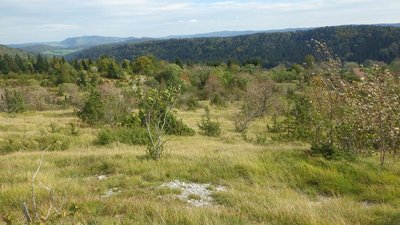
- Pierre Levisse - PNRHJ Natural environmentsDry grasslands
The path that leads up to the peak takes a short journey through sparse vegetation, called dry grasslands. This is where a vegetal diversity that is unique to calcareous slabs and rocks can be found. In addition to various orchids, the successive blooming of various small plants is as remarkable as the diversity of shrubs such as the alemanchier, common barberry or Mougeot's whitebeam.
The Peak is a favoured observation post to see the common raven or the peregrine falcon. These two species nest on the nearby cliffs.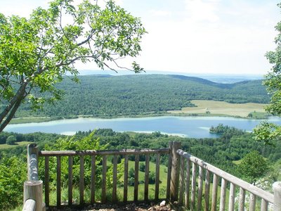
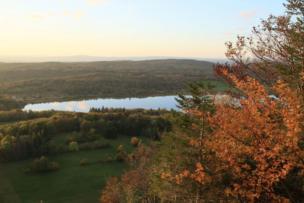
Belvédère du Pic de l'Aigle - OT Grandvaux ViewpointBelvedere of the Pic de l’Aigle (Eagle’s peak)
“A large staircase with a handrail and a few steps carved into the rock will lead you to an altitude of 990m. From there unfolds a wide panorama, well described by the observation post. The High-Jura is visible in-depth, with the lines of the successive ridges of its forest and the naked roundness of the Jura mountains. Beyond, the Mont Blanc is also visible near the Givrine pass. Over by the Ain combe, the distant relief of the Mâconnais appear in a bluish blur.”
Marc Forestier (“Que faire dans le Parc naturel régional du Haut-Jura”, What to do in the High-Jura Regional Natural Park, Dakota Edition)
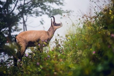
Chamois - Léo Poudré - PNRHJ FaunaThe Chamois, an unparalleled mountaineer
Whilst the Chamois is capable of travelling across a 1,000-meter incline in a quarter of an hour, most hikers are only able to climb 1,000 meters in 3 hours. Even an experienced athlete would need one hour to climb such an incline. If the Chamois is such a good climber it is because it has an enlarged heart that is capable of pumping blood through its body at an alarming rate, twice as fast as a human heart, and because it has hooves with two nails that can separate for better adherence to the rocks. A partition between its “fingers”, covered with fur, prevents it from delving too deep into the snow, in a similar way to our snowshoes.
Meeting this species, like others, is very much a question of luck and a significant amount of patience! But once you glimpse one, do not move and it will allow you to watch it for a good while.
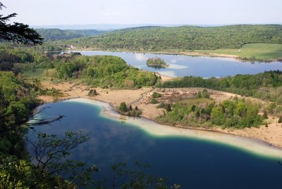
Lacs d'Ilay et Grand Maclu - OT Grandvaux ViewpointBelvedere of the Three Lakes
The “lagoon” colours of these lakes is a result of the formation of a “limestone vegetation ledge” around them. The shallow waters near the bank warm faster. Due to a chemical reaction, “hot” water is less capable of dissolving CO2. More abundant phytoplankton “absorb” the CO2 dissolved through photosynthesis. Water acidity is therefore slightly reduced. These two factors, when combined, mean that the calcite “drips” and forms “white mud”, full of chalk.
Belvédère des 4 lacs en automne - OT Grandvaux ViewpointBelvedere of the Four Lakes
The belvedere of the 4 lakes provides an overall view over the valley of the lakes, a remnant of the last glaciation: Narlay, Ilay, the Petit Maclu and the Grand Maclu. Do you know the legend of the Lake of Narlay? It is said that it covers the location of a village flooded by water. One Christmas night, a faerie requested asylum for one night from all of its inhabitants, in vain, as only the poorest of them offered her refuge. Angered, the next day, the faerie flooded the entire village, save for her host’s home located on the edge of the lake. The new village of Narlay was rebuilt around the house that was spared, but every year, at Christmas, the cockerel in the drowned village signs for the twelve strikes of midnight.
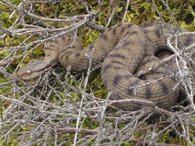
La Vipère aspic - S. Moncorge FaunaThe asp viper
Widely present in the marsh area between the Petit Maclu and the Grand Maclu, the asp viper is a poor swimmer and seeks sunny areas to ensure its metabolism can function properly. Like many reptiles, it is fearful and has a talent for detecting vibrations. To avoid bothering this species and being bitten, stamp your feet and be careful not to squash it, it will hide well before you even see it!
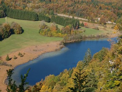
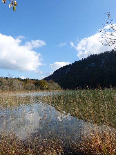
Entre Maclu et Ilay - B. Leroy Lakes & RiversNatural lakes, a fragile heritage
The waters of the Petit Maclu and the Grand Maclu feed the lake of Ilay. Each occupies a shallow basin dug out by the glaciers around 20,000 years ago.
These lakes are mainly surrounded by a wide diversity of vegetation, called low-marshes, wet tall-herb and fern fringes or peat bogs. Some reed beds also develop there. Insects flourish here due to the high quality of the environment, in particular dragonflies who vary in colour. The Eurasian coot is the most faithful bird to these lakes. Not very discreet, it is recognisable by its trumpeting cries of warning.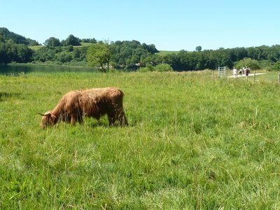
Un site naturel géré - S. Moncorge Natural environmentsA natural managed site
The Franche-Comté conservatory for natural areas manages the wetlands on the 4 lakes site in partnership with the owning municipalities and local farmers. This site is fill of species specific to open environments which must be preserved.
Once used by farmers, these zones have gradually been abandoned. This is why managers have made maintaining this type of environment a priority by reinstating extensive grazing.
Highland Cattle cows are able to move around on waterlogged soil and find the food that they need. The amount of cattle and grazing periods are adapted depending on the species and environments in question.
A site sheet dedicated to the wetlands on the 4 lakes site is available online:
http://cen-franchecomte.org/document.php?iddoc=63DyRcgMw7YQ42PG
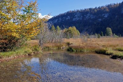
Lac d'Ilay - Gilles Prost - PNRHJ History & HeritageThe island of La Motte
Centred between the banks of the lake of Ilay is an island: the island of La Motte. Archaeological excavations have revealed that is was home to three successive religious establishments. An initial church was erected around the year 1,000 and seems to have burned down. After being rebuilt, a vestibule was added to it by a monastic congregation that ended up abandoning the place. Of the third establishment, we know only that it was abandoned during the 15th century. A wooden bridge provided access to the structure from the bank and the marshes that are now present were once orchards and pastures.
Description
From the PEAK PARKING LOT, the rocky trail ascends (yellow waymarking) to the north until it reaches the Foot of the peak across a healthy dry lawn. After climbing a steep slope (white and red waymarking) for 200 m, you will reach the PIC DE L’AIGLE.
The walk continues to the northeast winding along the wooded ridge. It nears a forest road twice and leads to the Belvedere of the Three Lakes, Ilay, Great Maclu and Little Maclu.
Staying on the edge of the ridge, a stony trail will lead you to the BELVEDERE OF THE FOUR LAKES (interpretive sign) surrounded by fir trees.
The trail ascends to the right towards the Belvedere Parking Lot, below the Ban forest road.
The path to the left - an extension of another trail - follows along the ridge marked by a set of cliffs without ever approaching it. After a quick winding descent, which can be slippery during humid weather, the trail meets the edge of the D 75 at the Côte du Maclu.
Using the cycling lane to the left of the roadside (yellow waymarking), head to the LITTLE MACLU LAKE (parking lot). The path then follows along the Little Maclu and Grand Maclu lakes towards Ilay. From the Chemin des Lacs, the road to the left opens onto les Rousselets and its chapel, nestled between two trees.
Follow the road to the left (white and red waymarking) and take a trail that crosses the D39 twice. The well-delineated path (former tramline) gradually ascends towards "Chemin du Château". The trail then becomes steep until it reaches the Foot of the peak. From here, you can head back to your starting point (yellow waymarking).
- Departure : Pic de l'Aigle parking lot in Chaux-du-Dombief
- Arrival : Pic de l'Aigle parking lot in Chaux-du-Dombief
- Towns crossed : La Chaux-Du-Dombief and Le Frasnois
Forecast
Altimetric profile
Sensitive areas
- Impacted practices:
- Aerial, Aquatic, Amenities, Underground, Land-based
- Sensitivity periods:
- AprMayJunJulAugSep
- Contact:
- Parc naturel régional du Haut-Jura
29 Le Village
39310 Lajoux
03 84 34 12 30
www.parc-haut-jura.fr/
Recommandations
Be careful, in the winter, the walk up to the pic de l'Aigle can be slippery due to ice: know when to stop! There is a steep and sometimes slippery section in the descent to access the lakes.
This trail passes through pastures with livestock and forest paths. To respect the owners and farmers granting you passage, and for the security of livestock and wild fauna, we ask that you remain on the waymarked paths.
Use the adapted passageways to get across fencing and be sure to close gateways behind you. Please keep your dog on a lead if you have one.
Wild flowers are beautiful, they may be rare and protected and often wilt quickly. Do not pick them! They will delight the next hikers.
In case of forest works (felling, skidding, etc.), for your safety, know when to stop and turn around.
Information desks

Tourist information centre - Haut-Jura Grandvaux
7 place Simone Veil, 39150 Saint-Laurent-en-Grandvaux
Transport
To visit and get about in the High-Jura, visit www.reshaut-jura.fr, the eco-mobility portal listing all means of transport within the Park.
Access and parking
10 km northwest of Saint-Laurent-en-Grandvaux via the D 678.
Parking :
Report a problem or an error
If you have found an error on this page or if you have noticed any problems during your hike, please report them to us here:
Close by1
Laid-out site
Belvedere of the Pic de l’Aigle (Eagle’s peak)
On the windy top of the Pic de l’Aigle, the landscape is yours to admire. To the west, the two main plateaus that mark the start of the Jura’s relief stretch out before you. The rocky ledge where the Pic de l’Aigle culminates and the lake region mark a break with the relief’s third plateau which is located to the east and gives way to the folded structures of the Jura’s high valleys.