The Doubs' source
11 points of interest
Hôtel de ville de Mouthe - History & HeritageMouthe Town Hall
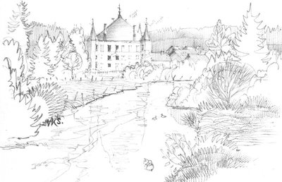
This building dated 1849, designed in the style of a Renaissance chateau under the reign of Louis Philippe, is flanked by four polygonal towers. The towers were originally covered in wood shingles which were replaced with zinc. The Mouthe town hall is registered on the complementary inventory of Historical Monuments since 21 June 1990.
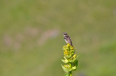
Le Tarier des prés - Fabrice Croset FaunaThe whinchat
In the spring, the whinchat returns to its vantage points above the High-Jura prairies. A post, a higher plant... From these strategic positions it sings a dry-sounding song and the male is easily recognised by its white brow. This bird lays its eggs on the ground in the prairie. However, earlier mowing of hayfields due to climate change and changes in agricultural practices mean that many young do not have time to learn to fly in time to head to Africa.
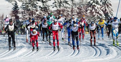
Transjurassienne - History & HeritageThe Transjurassienne
In Mouthe, 4,500 participants cross the finishing line to this race that has become the largest popular French Nordic ski event. Created in 1979, this race pits competitors against each other in various events, in classical styles and in skating, and passes through the départements of the Jura and of the Doubs.
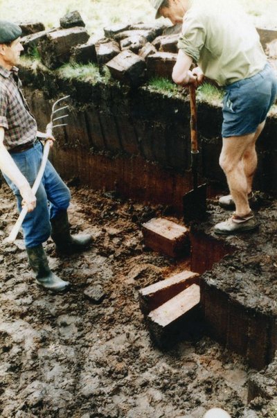
Extraction de tourbe - History & HeritageExploitation of the peat by Man
During the 18th century, with dwindling wood resources, inhabitants of the High-Jura turned to another less-efficient combustible: the peat. Once dried, it burns slowly with a characteristic pungent smell. Its extraction was carried out in spring, and then the bricks were piled into “lanterns” throughout the summer. Finally, they were stored in barns to dry before being used. Save for rare exceptions, in the High-Jura, this combustible ceased being exploited in the 1950s. The mounds that can been seen from the adapted platform are traces of this peat bog's past exploitation.
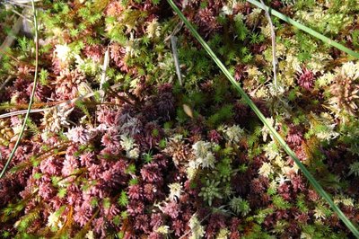
Sphaignes - Marion Brunel - PNRHJ FloraPeat moss
This moss grows on soil engorged with water, where “food” is limited. Like a sponge, this moss is able to store up to 30 times its weight in water. They grow from their upper extremity and die at the base. By releasing acidic compounds, they limit competition amongst other plants and prevent the development of organisms that contribute towards deteriorating organic matter. The older layers of peat moss do not rot, or they do so very little: their accumulation produces peat at a rate of 3 to 5 cm per century.
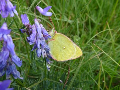
Solitaire - Pierre Durlet - PNRHJ FaunaThe moorland clouded yellow, inseparable from its peat bogs
The moorland clouded yellow lives near peat bogs, where the bog bilberry grows, its host plant. It deposits its eggs onto its leaves, which also serve to feed the caterpillar. It is as a caterpillar that the moorland clouded yellow spends its winter, before turning into a chrysalis in the spring and being born into this beautiful yellow butterfly. In June and July, the adult butterfly gathers pollen in the surrounding wetlands, fluttering from flower to flower.
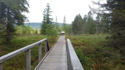
Tourbière du moutat - Pierre Levisse - PNRHJ Natural environmentsThe Moutat peat bog
A wooden boardwalk allows visitors to enter the peat bog’s environment without deteriorating it. The peat is a result of the slow accumulation of plants that do not deteriorate due to the permanent humidity of the site. This peat is a large stock of trapped carbon. Did you know that a drying peat bog a size of a football field releases as much CO2 in the atmosphere as a family car travelling 145,000 km, i.e. 3.5 times around the Earth.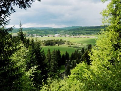
Belvédère - Gilles Prost - PNRHJ ViewpointBelvedere of the source of the Doubs
At the top of a small rocky cirque, the belvedere offers a full view over the Mouthe valley. In the foreground, the first meanders of the Doubs and the Moutat peat bog can be seen, in the distance is the village of Mouth, where you can easily make out the Comptois bell tower of its church.
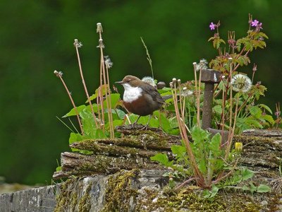
Cingle Plongeur - Fabrice Croset FaunaThe Dipper
A typical host of rapid rivers and stony bed torrents, the dipper, also called the “water blackbird”, is easily recognisable from the white patch on its breast that contrasts with the rest of its reddish-brown body. The male and female have similar plumage. This short-tailed aquatic passerine is both tall and stocky. Of a nervous disposition, you may see it on a rock along the banks, continually dipping on its “springy” legs.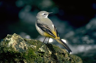
Bergeronnette des ruisseaux - Claude Nardin FaunaThe grey wagtail
The grey wagtail is very dependent on water. It loves running waters, where it finds most of its food: insects, both aquatic and other, larvae, etc., that it finds on the ground or on the waterside. You will often find it on a rock near the source. It is an elegant-looking bird, with a long tail and pink-coloured feet.
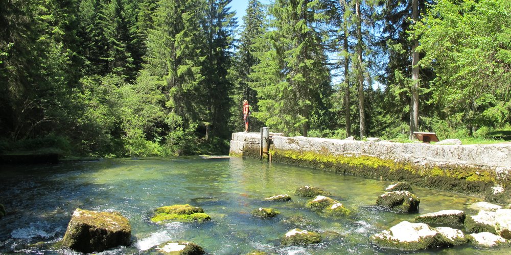
Source du Doubs - GTJ Lakes & RiversThe source of the Doubs
Springing from a 55-meter-deep siphon, the waters exit a deep cavity which has only been partially explored up until now. Galleries are fed by the water falling onto the Risol massif and infiltrating into the limestone cracks. The temperature of the water on exiting the cavity is never more than 6 degrees. From its source to the Saone into which it runs, the Doubs travels a distance of 458 km, when both points are only separated by 90 km as the crow flies!
Description
From the MOUTHE TOWN HALL, at the heart of the village, the itinerary heads off to the right (white and red waymarking) on the road towards the Doubs' source, goes past the church and the presbytery before coming to the Hike Starting Point.
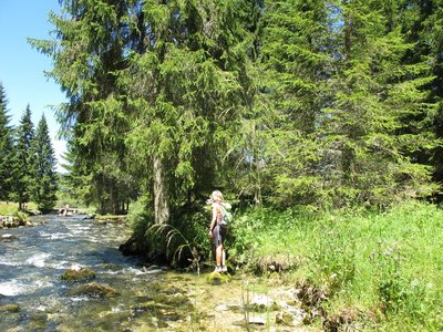
Via "rue du Moutat" to your right (yellow and blue waymarking) the trail continues on a small very flat road which, after crossing the Doubs, is bordered by damp meadows until it reaches "Route du Mouthat". Walk along the side of the road to the left for 100m. At Bas du Gît, the road to the left bordered by meadows, and later by a peat bog (boardwalk and informational sign), easily leads to the DOUBS SOURCE.
The trail heads up the river, following its right embankment, before reaching its source. The adapted trail provides a 300-meter circuit to access a belvedere via a few steps before heading back down and will help you learn about the Doubs and its secrets.
Once back near the bridge over the Doubs, a small well-adapted path (white and red waymarking) heads along the river towards Mouthe via "Chemin de la Source".
- Departure : Mouthe
- Arrival : Mouthe
- Towns crossed : Mouthe
Forecast
Sensitive areas
- Impacted practices:
- Aquatic,
- Sensitivity periods:
- JanFebMarAprMayJunJulAugSepOctNovDec
- Contact:
- Parc naturel régional du Haut-Jura
29 Le Village
39310 Lajoux
03 84 34 12 30
www.parc-haut-jura.fr/
Recommandations
Use the adapted passageways to get across fencing and ensure to close gateways behind you.
Lastly, please keep your dog on a lead if you have one.
Wild flowers are beautiful, they may be rare and protected and often wilt quickly. Do not pick them! They will delight the next hikers.
In case of forest works (felling, skidding, etc.), for your safety, know when to stop and turn around.
Information desks

Tourist information centre - Val de Mouthe
3 bis rue de la Varée, 25240 Mouthe
Transport
To visit and get about in the High-Jura, visit www.reshaut-jura.fr, the eco-mobility portal listing all means of transport within the Park.
Access and parking
Parking :
Report a problem or an error
If you have found an error on this page or if you have noticed any problems during your hike, please report them to us here: