The Mont d'Or and its chalets
7 points of interest
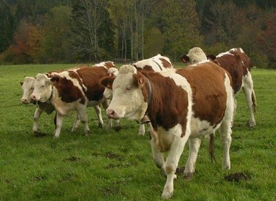
Génisses - Gilles Prost - PNRHJ Pastoralism and agricultureThe alpine pasture
Between the end of May and the end of September, it’s the summer season. However, on this cheese-making mountain, there are almost no milking cows still in the alpine pasture. These pastures have become home mainly to heifers, young females that have not yet calved. The production of Comté and of Morbier happens “at the bottom”, in the valley. And although the Mont d’Or mountain bears the name of another famous cheese, it is only during the long Jura winter, in the stables, that cows produce the milk for this specific cheese.
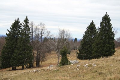
Epicéa toupie - Marion Brunel - PNRHJ Pastoralism and agricultureWoodlands and “spinning top” spruces
In the Jura Arc, men have designed areas in which cattle farming and the exploitation of wood coexist, shaping distinctive landscapes and particular biodiversity: woodlands. A symbol of this coexistence, “spinning top” spruces owe their unique form to the teeth of livestock. To survive their grazing, the tree reacts with a thick branching, mirroring a tree shaped like a bonsai.
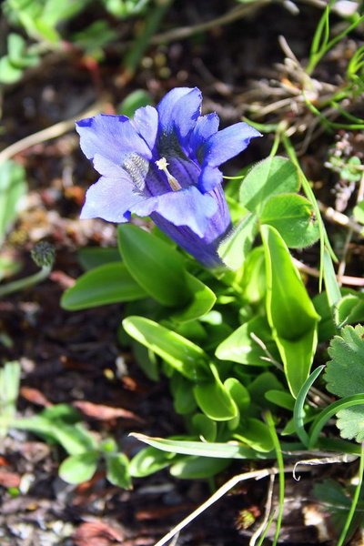
Gentiane de Koch - Marion Brunel - PNRHJ FloraThe Stemless Gentian
In the pastures below the Mont d’Or, deep blue trumpet flowers draw the eye. The Stemless Gentian (or Kock’s Gentian) is a species whose rarity equals its beauty. It owes its name (acaulis = “stemless”) to its very short stem. It blooms quite early in the season; the months of May or June should be preferred to be lucky enough to see one. Be careful, this is a protected species in the Franche-Comté region, hikers must therefore content themselves with observing them, and must not pick them! Here, it can be found with its very similar cousin, the Clusus Gentian. To tell the difference, you will need a lot of patience.
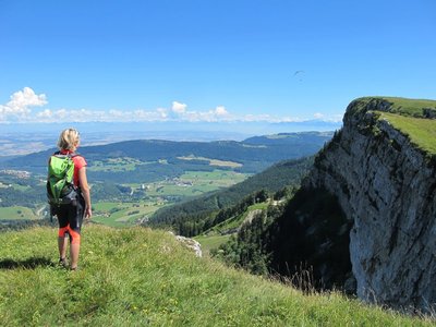
Mont d'Or - GTJ FloraThe treasures of the Mont d’Or ridge
A true “botanical garden”, the high-altitude lawns of the Mont d’Or ridge are home to exceptional floral diversity. Rare flowers, such as the Pulsatilla alpina or the Nigritella have found refuge here. As part of a rational development policy, this exceptional site has been classed a Sensitive Natural Area by the Département of Doubs and has also been included in the European network of protected Natura 2000 sites. These classifications aim to reconcile human activities with environmental sensitivities, thereby allowing to protect and highlight the area whilst ensuring the territory’s economic viability.
To find out more, visit: www.doubs.fr/index.php/les-espaces-naturels-sensibles.
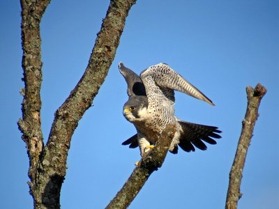
Faucon Pèlerin - Fabrice Croset FaunaThe Peregrine Falcon
This raptor is mainly avivore, i.e. the main part of its diet is comprised of birds, that it catches mid-air at dizzying lightening speeds of up to 350 km/h. From their lookout, they observe they prey and then fly to higher altitudes before launching a dive attack with “closed wings” from the bird’s blind spot. The cliffs of the Mont d’Or provide the Peregrine Falcom with an ideal habitat to nest.
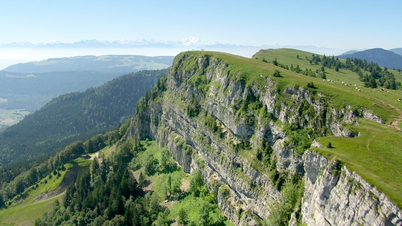
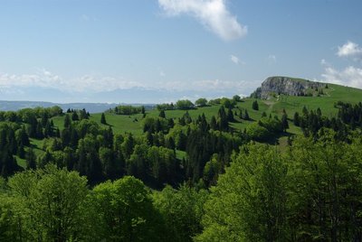
Mont d'Or - GTJ Peak – ViewpointViewpoint from the Mont d’Or summit
With a 360° panorama, the summit of the Mont d’Or offers a magnificent point of view. To take in one of the characteristics of the Jura Massif’s geomorphology, using photography, spot the two ridges “le Suchet” and “les Aiguilles de Bailmes” and the axial valley separating them. The valley is the result of hundreds of thousands of years of erosion at the summit of the same anticline.
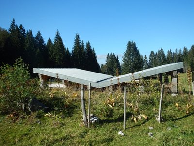
Couvert récupération d'eau de pluie - Marion Brunel - PNRHJ Pastoralism and agricultureWater in the summer
With water being rare in the summer period due to the karstic subsoil, made up of fissures and faults in the limestone, which it rapidly infiltrates, man has resorted to various mechanisms to retain and store it. The cover is a traditional rainwater recovery tool, particularly in Haut-Doubs summer pastures. It offers the necessary recovery area to fill underground cisterns and allows the installation of drinking spots for cattle far from chalets.
Description
From LES GRANGES RAGUIN (white and red waymarking), the trail follows the road towards the Mont d’Or over a short distance, before branching off to the left through a small clearing to take a forest path. A trail marked out in the pasture will bring you to LA BOISSAUDE. Still ascending in the same direction, through an open area scattered with mountain chalets, the trail cuts across "route de la Coquille" before joining the Mont d’Or access road and the Pastures of la Grangette.
After crossing the Mont d’Or parking lot, the trail (yellow and blue waymarking) opens out onto the MONT D’OR CLIFFS, with a first summit at 1,461 m, before following the ridge southwards to the Mont d’Or at 1,463 m.
Following along the panoramic ridge, the trail meets the Franco-Swiss border near the Mont d’Or cabin and runs along the right of the border wall to pass by the Gym cabin. At marker 72, the circuit branches off to the right into the combe (grassy path in the pasture), and joins up with the road to the Grande Échelle chalet. The road descends towards la Petite Échelle (gîte stopover and discovery farm), and then ascends to the right along the edge of the forest.
The trail takes a forest path to the left, before crossing the combe. It meanders through a forest section and opens onto "route du Haut Soulier". After 500 m on a gravel path, the circuit branches off to the right on a stone path through a wooded area and meets up with "Chemin de Corneau" and (white and red waymarking) the parking lot where you started in LES GRANGES RAGUIN.- Departure : Les Granges Raguin near Rochejean
- Arrival : Les Granges Raguin near Rochejean
- Towns crossed : Rochejean, Longevilles-Mont-D'Or, and Jougne
Forecast
Altimetric profile
Sensitive areas
Western capercaillie
- Impacted practices:
- , Land-based
- Sensitivity periods:
- JanFebMarAprMayJunDec
- Contact:
Recommandations
Take care along the cliffs of the Mont d'Or ridge.
This trail passes through pastures with livestock, follows trails along the summit ridge on fragile ground and makes use of forest paths. To respect the owners and farmers granting you passage, and for the security of livestock and wild fauna, and to limit erosion on the trails, we ask that you remain on the waymarked paths. Use the adapted passageways to get across fencing and be sure to close gateways behind you. Lastly, please keep your dog on a lead if you have one.
Wild flowers are beautiful, they may be rare and protected and often wilt quickly. Do not pick them! They will delight the next hikers.
In case of forest works (felling, skidding, etc.), for your safety, know when to stop and turn around.
Information desks

Tourist information centre - Métabief
6 place Xavier Authier, F-25370 Métabief
Transport
To visit and get about in the High-Jura, visit www.reshaut-jura.fr, the eco-mobility portal listing all means of transport within the Park.
Access and parking
Parking :
Report a problem or an error
If you have found an error on this page or if you have noticed any problems during your hike, please report them to us here: