Around Longchaumois
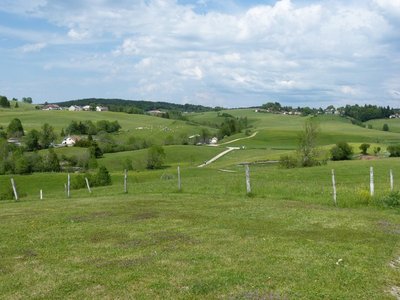
The long pastures still mark this landscape, which was cleared as from the Middle Ages, and stretch out into combes used for agricultural purposes around the village of Longchaumois. It is said that these pastures gave the village its name: longa calma during the 7th century or “longue chaume” (long pasture).
7 points of interest
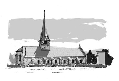
L'église de Longchaumois - History & HeritageThe Longchaumois church
Likely built during the 16th century, the gothic-style Longchaumois church was competed or made bigger during the 17th century as attested to by the date engraved on the stone above the entrance gate (1631).
The church underwent several other changes at the end of the 19th century, including the upgrading of the facades and the opening of bays.
The church’s uniqueness is provided by the sleek polygonal arrow topped with four bell turrets as well as by its wooden polychrome sculptures, some of which are classed as historical monuments and which date back to the 16th century. (PNRHJ - Collection patrimoine, “Heritage collection”)
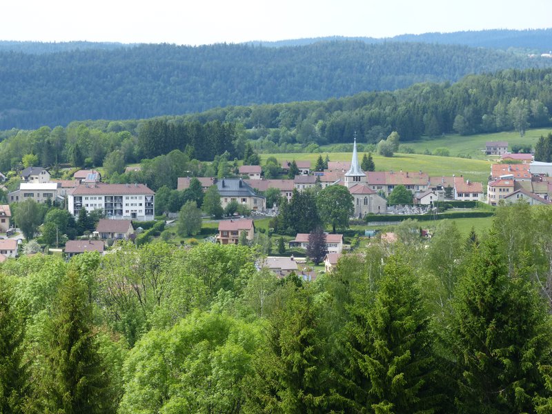
Village de Longchaumois - F. Jeanparis History & HeritageThe village of Longchaumois
Longchaumois is one of the villages considered the most representative of the High Jura in terms of traditional typology: a village centre with attached houses joined at the gable that stretch along the main road, and a scattering of several small hamlets and isolated houses across the municipal land. From the front of the church, which dates back to the 16th century, you can see how the vegetable gardens are organised behind the houses.
t'es la cuison - History & Heritage“t'es la cuison”
"T'es la cuison" or "t'es souci" or "t'es inquiet" are phrases in Patois, a French local dialect. They are said to be how Claude Prost came to get his war nickname Capitaine Lacuzon.
Born in Sous le Daim in Longchaumois around 1607, Lacuzon is a historical figure of the Franche-Comté’s resistance to its attachment to France, which occurred under Louis XIV in 1674.
A hero in Xavier de Montepin’s novel “Le Médecin des Pauvres”, Capitaine Lacuzon is still a controversial character to many historians.
To find out more, visit: http://www.mes-annees-50.fr/capitaine_lacuson.htm.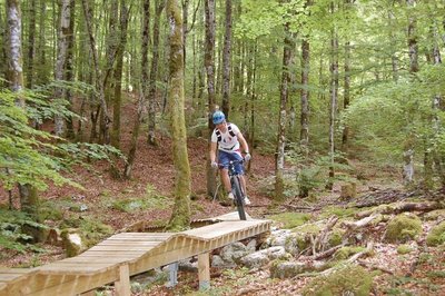
Le Bike Parc de Longchaumois - Leisure zoneThe Longchaumois Bike Park
A unique innovation in the High Jura, the Longchaumois Bike Park has become unmissable for mountain bikers looking for some adrenaline.
Thought up and planned by François Billy-Maître, an experienced cyclist from the village, this site is mainly based on the notions of pleasure and sharing.
The park includes an initiation area comprised of banked corners, bridges, walkways and jumps as well as a practice area with over 6 km of descents accessible to cyclists of all levels.
Speed and thrills are guaranteed in this privileged natural area.
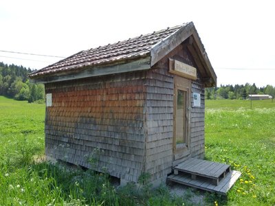
Le grenier fort - History & Heritage“Grenier fort” (strong attic)
Born from the ingenuity of master carpenters in a frontier land with a dark past and a difficult climate, the “grenier fort” - here in the “Longchaumois” style - is a testament to the wood civilisation having marked the Jura mountain up until the 18th century. Cereals, food, clothes, precious objects, tools and writings were stored away from the fires that could ravage homes and far from rodents and jealous eyes.
In Rosset, this grenier fort was turned into a “book box” which is always open.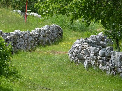
Vy à Baptaillard - Pastoralism and agricultureVy in Baptaillard
Bordered by two low stone walls, the “vy” or vie” is the path or route used to guide livestock from the farm to the pasture.
A mark left on the landscape by the past, “vies” and their low walls are home to a well-adjusted biodiversity. Its cracks contain real microhabitats and are beneficial to species such as the common wall lizard and the goldmoss stonecrop, a succulent plant with leaves full of reserves.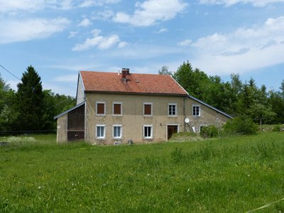
La ferme haut-jurassienne - Léo Poudré - PNRHJ History & HeritageThe High Jura farm
The traditional High Jura farm housed hay, wood provisions, animals and people, all under the same roof, with the latter benefitting from the heat provided by the former. Insulation was provided by the hay stored away for the winter, with the principle of the high barn.
However, water supply problems were more difficult due to the karstic nature of the widely cracked underground, and water sources were often lacking.Works were therefore launched, starting with the cistern. They continued with the assembly of the “column” framework which would make up the house’s skeleton. The roof was then built with wooden shingles (small spruce tiles). The gutters on the roof served to collect water to fill the cistern. Lastly, fat lime mortar could then be made to build up the walls.
Description
From the Information Point, near the Post Office (“La Poste”) in LONGCHAUMOIS (
 ) , head to “la grande Rue”, turn right and then left towards the Cheese Dairy (blue MTB waymarking no. 28), to take the road to Le Nid.
Continue on the road to the left and head to ORCIERES via Maison Gauthier, Route d’Orcières and Froide Fontaine.
The road to the left crosses over the Pissevieille rivulet. Ascend the path to the right towards Sous le Daim, before reaching the BIKE PARK DEPARTURE POINT (BIKE PARC DÉPART).
Follow the D 69 to the left, and at Les Combes, head up the white path to the right. Head past “en Pissard” and head to la Combe de Servagna.
The Road to the left at the bottom of the combe (an old sandpit is on your right) will lead you to Adrets des Riasses. Continue straight on the forest path before coming to Les Os.
Branch off left towards Tavaillonnette. (To quickly reach Longchaumois, continue straight taking the path and then the road).
Follow a trail to the right which borders the road, and then turn right before left onto a grassy path that will lead you to a crossroads. Cross over and follow the road until you come to ROSSET.
Follow the road to your left which, after a short ascent, heads down to Novet le Bas. Turn right and follow this rolling path until you come to the Le Cul de Sac hamlet. Head up the road to the left and follow the road via les Séchets to reach La Vigne.
Continue straight on this road for 350 m and take a grassy path to the left which heads around the back of La Ruchette. Continue until you reach the Les Adrets crossroads.
Continue straight for 500 m and join up with a road that heads down to the D 69. Cross with care, head between the houses and down the path and road that will lead you to BAPTAILLARDS.
Continue on the road through the hamlet before taking a sharp left turn before the last house, following a stony path. When you reach a path, turn right, head between the Souillet farms and continue past Sur le Villard. Head down the road to Le Nid.
Enter LONGCHAUMOIS via the road to your left.
- Departure : Longchaumois information point
- Arrival : Longchaumois information point
- Towns crossed : Longchaumois
Forecast
Altimetric profile
Recommandations
For an MTB outing, wear a helmet and bring enough water.
Paths are shared with pedestrians and horse riders, who have priority, therefore, please adapt and control your speed.
To use MTB paths, do not hesitate to get down from your bike.
This trail passes through pastures and forest paths. To respect the owners and farmers granting you passage, and for the security of livestock and wild fauna, we ask that you remain on the waymarked paths and close gates behind you where there are no MTB paths.
Wild flowers are beautiful, they may be rare and protected and often wilt quickly. Do not pick them! They will delight the next admirers.
In case of forest works (felling, skidding, etc.), for your safety, know when to stop and turn around.
Transport
To visit and get about in the High-Jura, visit www.reshaut-jura.fr, the eco-mobility portal listing all means of transport within the Park.
Access and parking
15 km north of Saint-Claude via the D 69 through Cinquétral and 13 km south of Morez - Hauts de Bienne via the D 69 through La Mouille.
Parking :
Report a problem or an error
If you have found an error on this page or if you have noticed any problems during your hike, please report them to us here: