The Roman road from Moirans
Boxwood forests, belvederes over the Vouglans lake, an ancient road and bouquets of flowers on the Sapey plateau.
10 points of interest
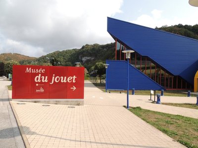
L'industrie du jouet - F. Jeanparis History & HeritageThe toy industry
Toys are testaments to the transition from a domestic economy to a market economy. During the mid-19th century, toys were just one of the many wood-turning products. The toy industry was in full expansion with the development of machinery, energy sources and commercial networks. During the 20th century, while the hand-crafted production method was still widely used, the industrialisation of toys truly started in the period between the wars, particularly with the specialisation and autonomisation of businesses. The toy sector came to reflect the transformation of industrial and commercial rationales: the generalisation of plastic materials, the acceleration of technological innovation, strong marketing growth, etc.
Paysage industriel - F. Jeanparis History & HeritageIndustrial landscape
The transition from a “family” economy to a market economy has led to a nuanced industrial landscape in which workshop farms, crafts buildings, cooperative factories and large modern production sites that are increasingly disconnected from local specificities are all present.
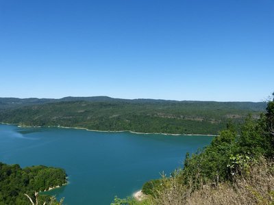
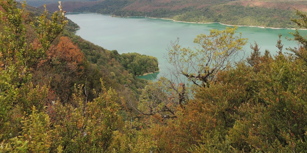
Point de vue du Bois de la Refrèche - ViewpointViewpoint from Bois de la Refrèche
Surrounded by the boxwood and bushes of Bois de la Refrèche, the landscape looks out over the waters of the Vouglans lake.
%20PNRHJ%20-%20Nina%20Verjus.jpg.400x0_q85.jpg)
Vue sur le lac de Vouglans - Nina Verjus - PNRHJ Lakes & RiversViewpoint over Vouglans lake
Built on the Ain, at 130 metres high, the Vouglans dam is the French dam with the 3rd highest storage capacity: it is capable of holding around 600 million cubic metres of water, and with 1600 hectares of water surface, it makes the Vouglans lake one of the largest artificial lakes in France. It took a year and a half to fill with water and it deeply changed the physiognomy of the Ain’s embankments, swallowing up several hamlets as well as the Chartreuse de Vaucluse, the first Carthusian monastery in the Jura (12th century).
La voie romaine - F. Jeanparis History & HeritageThe Roman Road
We don’t know much about this straight “Roman” path.
From Villard D’Héria, a village to the south of Moirans-en-Montagne, where the remains of a temple and of a cult and thermal complex can be found in one of the most remarkable Gallo-Roman sites of southern Franche-Comté, since the 2nd century, the main axis of this path runs from the Le Gouillat hamlet in the municipality of Charchilla, to the Sous la Razée hamlet in the municipality of Maisod.
From there, a path branches off towards a set of inhabited areas, around and on Mont River, another Gallo-Roman site near Champagnole. A second path crosses over the Ain and joins up with the other North-South roads towards Salins, Besançon or Lons-le-Saunier. This ford was replaced by a bridge during the 13th century, which was often destroyed but always rebuilt up until the Pont de la Pyle which currently bridges the gap over the Vouglans lake.
Pignons à redents - F. Jeanparis Know-howStepped gable
Called a “crow-stepped gable” or a “corbie gable”, stepped gables were used to prevent a fire spreading from one attached house to another. Positioning slates flat prevented the infiltration of water (with water being sent away from the facade).
In the countryside, this roof specificity is also typical in Bugey and Vercors (PNRHJ - Collection patrimoine, “Heritage collection).
Autour de la voie romaine - History & HeritageAround the Roman road
Here, on either side of the Roman road, there are still several characteristic stones. They appear to have served as foundations for crosses or stone gallows.
Used by pilgrims and traders headed to Saint-Claude during the Middles Ages up until 1845, this road was also used by famous figures such as Philip the Bold, Charles the Bold, Louis XI, Anne of Birttany, Francis de Sales, Jeanne de Cantal and Lamartine. Saint-Claude’s body was found intact in 1181, several centuries after his death, and ostentation processions took this path towards Lons-le-Saunier and Arbois.
The history of the road and of the Pont de Pyle bridge are discussed in the book “Histoire de Maisod et des territoires voisins” (The History of Maisod and neighbouring regions) written by J.M VUILLEMOT.%20PNRHJ%20-%20F.%20Jeanparis.jpg.400x0_q85.jpg)
Pelouses sèches - Nina Verjus - PNRHJ Natural environmentsDry grasslands
Thin soil, good sun exposure, low water-retention capacities and the almost complete absence of soil additives. Yet, dry grasslands are full of biodiversity: Mountain germander, Breckland thyme, laserwort and the military orchid are just some of the flower species that you may glimpse if you take the time to look. But please only use your eyes; over a quarter of protected species in France are from this environment. Drylands are disappearing due to the expansion of bushlands, caused by the abandonment of these lands that are more difficult to farm.
Coulouvre - Gilles Prost - PNRHJ History & HeritageCoulouvre
This place owes its name to the many vipers (“couleuvres” in French) that inhabit the now dry marshland close to the hamlet of Coulouvre. Three wood turning companies continue the tradition of manufacturing animal call instruments out of boxwood using traditional methods.
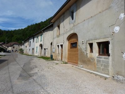
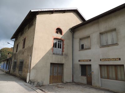
Coulouvre, hameau de Crenans - History & HeritageCoulouvre, the hamlet of Crenans
In the village, buildings are organised in “spans”, mainly due to constraints relating to adjoining houses. Thus, each span tied the building to a specific purpose: stables, barns or housing. Wind-break walls (or the advanced position of gable walls, on the main facade) are characteristic of rural houses in the High-Jura. Balconies, which provide a gallery on the main facade and serve to dry wood and crops, are fairly common architectural elements in this area. Rural buildings also demonstrate the strong relation between agricultural activities and craft activities.
Description
From the MOIRANS-EN-MONTAGNE signpost, (

 ), follow “route de Saint-Laurent” to the left in front of the high school (red MTB waymarking no. 108). Head past the cemetery and turn left in the industrial area. Head past the water treatment plant and continue right on the path that heads under the D 470 towards Sous le Pont.
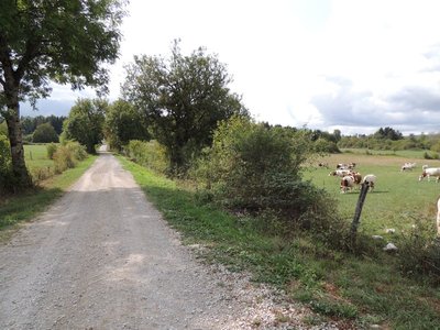
Reach En Var to your right via the white path and then take the muddy trail bordered by trees to your left to reach Champ Piernet.
Follow the grassy trail to your left that soon becomes stony and heads through the Bois de la Réfrèche with its two viewpoints over the Vouglans lake, before exiting at Les Araignées.
Follow the road that runs alongside the départementale road and ascend the bank to the Regardoir parking lot.
Soak up the view over the lake, head along the left of the parking lot and find the LE REGARDOIR crossroads; a trail burrows into the forest to your left.
Follow the path that is stony in places and that brushes along the départementale road, then take an abandoned road to reach an inn. Take the D 301 to your left for 40 m and turn right onto the white path parallel to the road. This straight path heads down below the church towards the Voie Romaine crossroads (a rather complicated crossroads, pay attention to the waymarking).
Head straight across the crossroads to follow the old roman road (red MTB waymarking no. 107) without really changing direction, crossing a road and coming to Sapey pasture (which fell victim to a fire in 2018 which deeply affected its landscape).
Turn right onto a white path through dry grasslands (cattle grids), head past En Sapoy and reach La Croix de Sac.
Take the underground road to your right that crosses under the D 470. Follow the road into the village to reach the MEUSSIA crossroads.
Take the first road on your right to the D 27 and follow the D 27 to La Guille.
Cross the road and take the shaded white path opposite you that gradually ascends into the forest. After a short descend into the pastures, reach the village of Coulouvre through Côte de Guy.
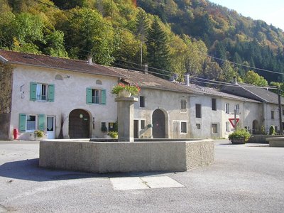
Head through the village, past COULOUVRE and En Chaspereille, and continue on the D 296 to a hamlet. Descend to your left on exiting the hamlet, using a path to the centre of the village of CRENANS (fountain). Taking the road to your left (Red MTB waymarking no. 108), head to Sous la Crochère.
Take the stony and earthy path to your right into the forest. Head past a sand pit and join up with a small road. Quickly turn left (discovery trail: The soaring lake) and follow a path that is very stony in places along a wetland, called l’Etang. Exit at La Bessoule onto a cement road.
Head up this steep road towards the left. Take the path to your left, just before a farm, through a clearing for 100 m (two agricultural gates to open and close) to head back down to La Montée de la Bessoule in Moirans-en-Montagne.
Cross the road and continue towards the Pierre Vernotte high school to the parking lot you started in.
- Departure : Moirans-en-Montagne, in front of the Pierre Vernotte high school
- Arrival : Moirans-en-Montagne, in front of the Pierre Vernotte high school
- Towns crossed : Moirans-En-Montagne, Charchilla, Maisod, Meussia, and Crenans
Forecast
Altimetric profile
Recommandations
For an MTB outing, wear a helmet and bring enough water.
Paths are shared with pedestrians and horse riders, who have priority, therefore, please adapt and control your speed.
To use MTB paths, do not hesitate to get down from your bike.
This trail passes through pastures and forest paths. To respect the owners and farmers granting you passage, and for the security of livestock and wild fauna, we ask that you remain on the waymarked paths and close gates behind you where there are no MTB paths.
Wild flowers are beautiful, they may be rare and protected and often wilt quickly. Do not pick them! They will delight the next admirers.
In case of forest works (felling, skidding, etc.), for your safety, know when to stop and turn around.
Information desks
Tourist information centre - Jura Sud
3 bis rue du Murgin, 39260 Moirans-en-Montagne
Transport
To visit and get about in the High-Jura, visit www.reshaut-jura.fr, the eco-mobility portal listing all means of transport within the Park.
Access and parking
20 km from Saint-Claude via the D 436 and the D 470, and 40 km from Lons-le-Saunier via the D 52 and the D 470 through Orgelet. In Moirans, follow signs for Pierre Vernotte high school, north of the town centre.
Parking :
Report a problem or an error
If you have found an error on this page or if you have noticed any problems during your hike, please report them to us here:
Close by2
Laid-out site
The Regardoir Belvedere
The Vouglans dam and the filling of the Ain valley with water over around forty kilometres in 1968 deeply transformed the landscape and the activities close to Moirans-en-Montagne.
The Regardoir Belvedere, located on the east side of the valley, opens onto the contemporary landscape of the Vouglans lake.