Trip around the Belvederes
Rolling paths, complemented by a few little trails and short ascents, make up this circuit which is perfectly refreshing.
5 points of interest
%20PNRHJ%20-%20F.%20Jeanparis.jpg.400x0_q85.jpg)
Vue sur le village de Giron - F. Jeanparis History & HeritageView over the village of Giron
The municipality of Giron was created in 1790, however its borders were only set much later in 1815. Before, the municipality was divided into two separate entities: “Giron-devant” which belonged to Champfromier, and “Giron-derrière” belonging to Échallon. The neo-classical style church was built in 1840 in Giron-Devant, in the most recent area of the village. Restored in 1902, it is also a symbol of the municipality’s religious and administrative. (PNRHJ - Collection patrimoine, “Heritage collection”)
%20PNRHJ%20-%20F.%20Jeanparis.jpg.400x0_q85.jpg)
Belvédère de l'Achat - F. Jeanparis ViewpointBelvedere of l’Achat
From the dry grasslands of the belvedere of l’Achat, cloistered by the Champfromier forest, the landscape opens onto the cirque of les Avalanches and its high limestone cliffs. You are currently on the hunting grounds used by many birds of prey (peregrine falcon, common buzzard, etc.), which you will have no difficulty spotting with a bit of patience.
%20PNRHJ%20-%20F.%20Jeanparis.jpg.400x0_q85.jpg)
Belvédère des Avalanches - F. Jeanparis ViewpointBelvedere of Les Avalanches
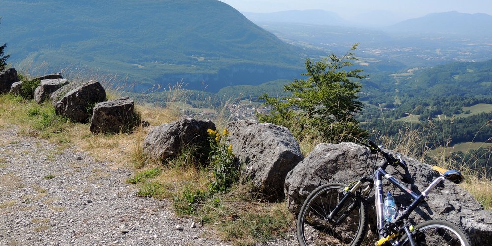
In front of you is the valley of the Valserine, a river whose source is located further north at the foot of the Dôle. Up to Chézery-Forens, the valley is bordered by the Jura mountains, and then opens onto the Haut-Bugey. There, the milder climate suits the orchards and cereal fields and industry has also developed along the waterway.
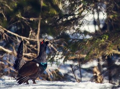
Le Grand tétras - Léo Poudré - PNRHJ FaunaThe western capercaillie
The Champfromier-Giron forest is home to one of the High-Jura’s most iconic birds: the western capercaillie. A sign of the diversity of high forests, this bird - also known as the wood grouse - is omnipresent here. The male favours old forests, while the female, who moves around more, prefers to spend her winters in bushy areas and raise her young in clearings.
This bird is particularly sensitive to disturbances in the winter and spring. There isn’t much chance of seeing one, but if you do, be sure to make the most of this extraordinary moment and stay quiet and on the waymarked paths.%20PNRHJ%20-%20F.%20Jeanparis.jpg.400x0_q85.jpg)
Belvédère de la Roche Fauconnière - F. Jeanparis ViewpointBelvedere of La Roche Fauconnière
From the Roche Fauconnière you will be able to see over the valley of the Semine, whose river has dug out a deep relief over millions of years.
An interpretive signpost will provide you with more information on the creation and development of this dizzying landscape.
Description
From the cemetery, at GIRON 1000 (

 ), take Rue du Grand Golet towards Le Cretet (blue MTB waymarking no. 9). Head up the tarmac road towards Combe Marin, in a wooded environment.
Reach La Croix via a muddy forest path that heads right.
When you reach La Croix, which offers a beautiful view over Giron, continue straight on a tarmac road up into the forest, towards Chemin Neuf.
Continue straight, head past the metal barrier and continue on the forest path for 400 m. Head up to your left (cross-country ski slope) into the forest via a muddy path towards Les Cinq Chalets, you will reach a viewpoint over Le Haut-Bugey, the southern part of the Jura massif.
Branch off to the left eastwards and stay on the forest path to reach a path suitable for vehicles at Pas du Boeuf.
Follow the path to your left for 250 m, and then head up to your right to reach the Achat viewpoint (viewpoint over the High Jura Chain, the Crêt de Chalam and the Les Avalanches cirque).
Follow this path to the right for 450 m, branch off to the right on a forest path for 700 m and then take another forest trail to your right towards Combe de l’Auger.
Make a round trip to the Belvedere of Les Avalanches to your right, heading through LES AVALANCHES (open view over the valley of the Valserine).
On returning to Combe sur l’Auger, take the little grassy trail to the north through a clearing before joining up with a forest path, towards the Chalet Cottin. Continue on the forest path towards Les Abrans.
Take the D 48a to your left for 800 m until you reach Le Bleu. Branch off to the right on a forest path and then continue on the muddy trail along a cliff (be careful!). Head past Les Ordières to reach the junction with La Roche Fauconnière.
The Belvedere of La Roche Fauconnière and its view over Les Roches d’Orvaz can be accessed in a round trip by ascending to the right.
When you return, take the forest path and then the forest road to Combe Marin. Return to your departure point the way you came.
- Departure : Giron
- Arrival : Giron
- Towns crossed : Giron and Champfromier
Forecast
Altimetric profile
Sensitive areas
Western capercaillie
- Impacted practices:
- , Land-based
- Sensitivity periods:
- JanFebMarAprMayJunDec
- Contact:
Recommandations
Be careful to remain on the paths when approaching the belvederes, particularly between Le Bleu and La Roche Fauconnière.
For an MTB outing, wear a helmet and bring enough water.
To cross MTB paths, do not hesitate to get down from your bike.
Paths are shared with pedestrians and horse riders, who have priority, therefore, please adapt and control your speed.
This circuit uses paths through the Giron-Champfromier forest, which is a remarkable high forest known for its biodiversity. To respect owners and farmers, and for the security of wild fauna, we ask that you remain on the waymarked paths during the spring, until 30 June.
Remember to close barriers behind you where there are no MTB paths.
Wild flowers are beautiful, they may be rare and protected and often wilt quickly. Do not pick them! They will delight the next admirers.
In case of forest works (felling, skidding, etc.), for your safety, know when to stop and turn around.
Information desks

Tourist information centre - Terre Valserine
71 rue de la République, 01200 Valserhône
Transport
To visit and get about in the High-Jura, visit www.reshaut-jura.fr, the eco-mobility portal listing all means of transport within the Park.
Access and parking
21 km from Bellegarde-sur-Valserine, via the D 1084 to Saint-Germain-de-Joux, and then the D 55, the D 33 and lastly the D 55 a.
Parking :
More information
Report a problem or an error
If you have found an error on this page or if you have noticed any problems during your hike, please report them to us here: