Around the Rocks of Orvaz
The diversity of its landscapes and paths makes this trail a pleasant and accessible one. The only possible difficulty resides in the forest paths in the Chapuzieux forest, which can be humid and muddy.
5 points of interest
Poljé de Chaudezembre - PNRHJ - F. Jeanparis GeologySmall polje of Chaudezembre
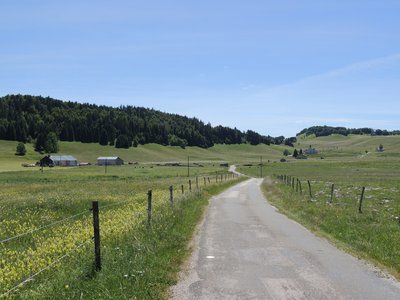
Look at the landscape around you. It might remind you of the Causses: a relatively flat and open area, bordered, particularly to the East, by a steep landscape covered in forest.
Called a polje, this geological formation is a closed depression of several kilometres in diameter, from which water evacuates by filtering through the limestone rocks.
Further away to your left, note the presence of slightly pronounced lapies, rising out of the pastures. These limestone rocks have been eroded by runoffs from rainwater and changes in temperature.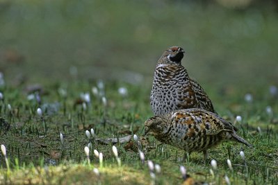
Gélinotte des bois - Jean-Lou Zimmermann FaunaThe Hazel Grouse, a very discreet bird
Barely bigger than a dwarf hen, the Hazel Grouse’s silhouette is rather large, with short legs and a short tail. Its plumage is subtly shaded and enables it to camouflage itself in its environment.
In spring, it feeds on the buds of hazel trees or other shrubs covering the forest floor. Very discreet, you may hear it quickly fly away on your arrival. Be careful, as from June, a subject that does not fly away may be looking to protect its young. Discreetly move away.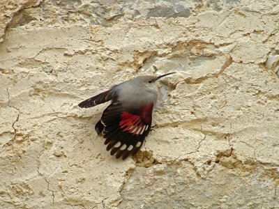
Tichodrome échelette - Fabrice Croset FaunaThe wallcreeper
A high-mountain bird during the summer, the wallcreeper heads for the Jura between autumn and spring. Roughly the size of a sparrow, you will have the most chance of seeing it on the cliffs. A tireless surveyor, it creeps along cliff walls in search of small insects or spiders in the cracks. You will recognise it by its bright red wings.
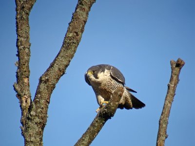
Faucon pèlerin - Fabrice Croset FaunaThe Peregrine Falcon
Loops, dizzying dives, chases: between February and March, during mating season, these birds pair up and put on spectacular shows in the sky. This bird of prey can reach speeds of up to 350 km/h when in a vertical dive. Its quickness means that it is able to catch other birds mid-flight to feed. This ability has been used by falconers as a hunting weapon.
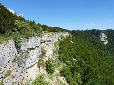
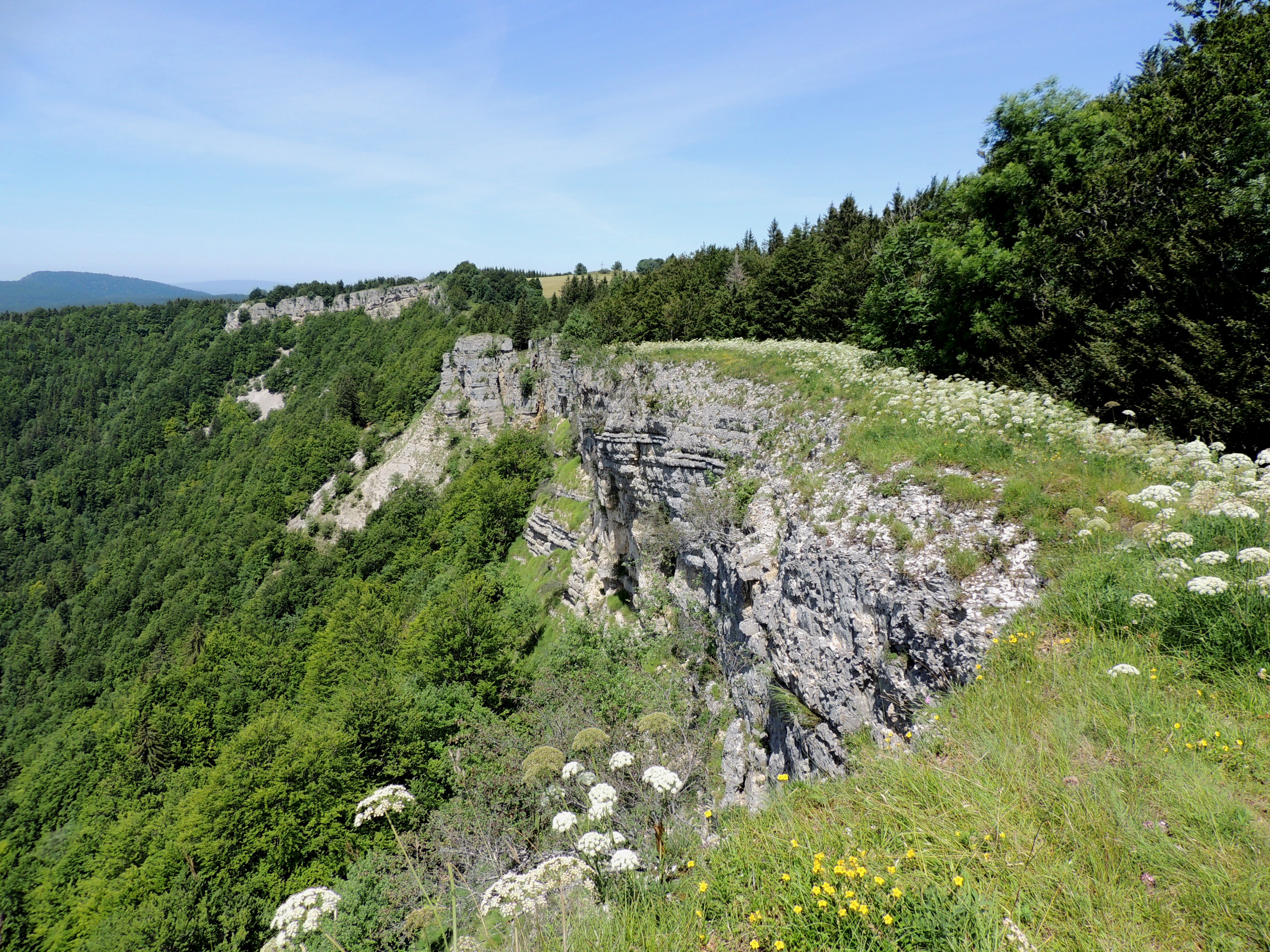
Roches d'Orvaz - PNRHJ / Gilles Prost Natural environmentsThe Rocks of Orvaz
This long and friable limestone cliff shows signs of erosion; faults spread from under your feet. (Take care when walking along the cliff and remain on the trail). The Rocks of Orvaz overlook the hamlet and the combe of Orvaz. Opposite the Roche Fauconnière (Falcon Rock), named after its resemblance to a falcon with wings outstretched, overlooks the Semine valley.
Description


 , head to the La Pesse church. Turn left (MTB waymark no. 39) up route de Chaudezembre, and then descend to the Chaudezembre hamlet.
 Continue left on a tarmac road surrounded by pastures, ascending up to The quarry.
Continue towards the Old Dairy for another 400 meters along this road, and then turn left at Cernois Bouiller, following a grassy path through a pasture.
From here, cut through a long forest on a succession of grassy, rocky and muddy paths, including a short section of forest path. As it is relatively flat, this part of the trail can become humid and requires that you be careful.
At the D25, head down the grassy, and later stony, trail on your left, joining up with the D25 400 meters further on at a hangar. Continue right on the D25 until you reach the Old Dairy.
Branch off to the left (with care), and ascend a small road until you reach the ROCKS OF ORVAZ viewpoint.
Continue on this road until you come to an adapted viewpoint (get off your bike).
On returning to the road, continue towards le Montelet. Branch off to the left on a forest path, then take a muddy and stony path that opens onto the Cernétrou woods.
Reach the Pass in Sur la Semine via a little grassy path to the left through the middle of pastures, and equipped with MTB paths, before joining up with the D25 once more.
Take this road to return to the La Pesse church.
- Departure : La Pesse church
- Arrival : La Pesse church
- Towns crossed : La Pesse, Les Bouchoux, and Belleydoux
Forecast
Altimetric profile
Sensitive areas
Western capercaillie
- Impacted practices:
- , Land-based
- Sensitivity periods:
- JanFebMarAprMayJunDec
- Contact:
Recommandations
Be careful when crossing the road at the Old Dairy.
Be careful along the edge of the Rocks of Orvaz cliffs.
For an MTB outing, wear a helmet and bring enough water.
Paths are shared with pedestrians and horse riders, who have priority, therefore, please adapt and control your speed.
To use MTB paths, do not hesitate to get down from your bike.
This trail passes through pastures and forest paths. To respect the owners and farmers granting you passage, and for the security of livestock and wild fauna, we ask that you remain on the waymarked paths and close gates behind you where there are no MTB paths.
Wild flowers are beautiful, they may be rare and protected and often wilt quickly. Do not pick them! They will delight the next admirers.
In case of forest works (felling, skidding, etc.), for your safety, know when to stop and turn around.
Information desks

Tourist information centre - Haut-Jura Saint-Claude
3 place de l'Abbaye, 39200 Saint-Claude
Transport
To visit and get about in the High-Jura, visit www.reshaut-jura.fr, the eco-mobility portal listing all means of transport within the Park.
Access and parking
15 km south of Saint-Claude via the D D124 and the D25.
Parking :
Report a problem or an error
If you have found an error on this page or if you have noticed any problems during your hike, please report them to us here: