
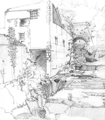
The Giant’s cauldrons
At the heart of the folded Jura, water and limestone play a tricky game. Infiltration, dissolution, and subterranean circulation have created a series of surprising phenomena, waiting to be discovered during this hike.
5 points of interest
Scierie Thévenin - History & HeritageThévenin sawmill
At the foot of Saint-Germain-de-Joux, the Combet river rushes into one last waterfall before converging with the Semine. During the early 1900s, the Thévenin sawmill decided to upsize to fully benefit from this high flow rate. At the time, it had a “giant” 7.5-meter-high water wheel which would run day and night, to match the rhythm of arrivals and orders. Housed just downstream from the sawmill, the sawyers would work hard around the clock. In 1859, a diamond factory set up in this restricted perimeter - which was highly sought after in the first part of the 19th century due to its hydropower installations - just downstream from the sawmill and the Romain bridge.
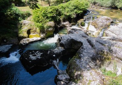
Les marmites de Géant - Nina Verjus - PNRHJ GeologyThe Giant’s kettles
In Saint-Germain-de-Joux, the erosion caused by the Semine and its tributary, the Combet, creates huge holes called potholes or “kettles”. Measuring two to three metres deep, they are linked together by a few successive waterfalls, where the famous brown trout can be found. Keep your eyes peeled, you may also come across the yellow-bellied toad, a rare species of toad.
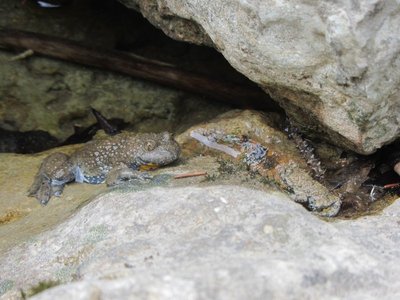
Le Sonneur à ventre jaune - Julien Barlet - PNRHJ FaunaThe yellow-bellied toad
This small toad with a grey, brown or olive-coloured back has a bright yellow underbelly and throat, which serves to warn any nearby predators of its toxicity. Its skin gives off venom that can cause unpleasant burns. If you look closely at the picture, you will notice its heart-shaped eyes! Is your prince charming a yellow-bellied toad?
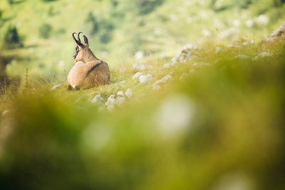
Le Chamois - Léo Poudré - PNRHJ FaunaThe Chamois
The Chamois has an entirely unique look, which it owes to its two black, poker-straight horns with hook-like ends. Both males and females have horns, that they keep for life and grow every year - unlike stags and deer who lose their antlers. The colour of their coat varies according to the season, but all chamois have a dark band along their back. The top front part of their head and their cheeks are white and are divided by a black band that runs from their ears to their muzzle.
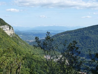
Point de vue de la Roche à l'Aigle - ViewpointViewpoint from the Roche à l’Aigle
The rocky promontory of the Roche à l’Aigle overlooks the village of Saint-Germain-de-Joux and the valley of the Semine river. It also offers a wide and in-depth view from the south-east of the Alpine massif around Annecy to Plagne in the north, a village known for the marks left behind by the dinosaurs tens of millions of years ago.
Description
From SAINT-GERMAIN-DE-JOUX, head down the village (yellow waymarking) towards Bellegard and then follow “rue de la Gare” for 50m. Branch off to the left and head down a trail that opens onto the Romain bridge. Head up the road opposite you for 30 m.
Take a descent to the left to cross the Semine at the GIANT’S CAULDRONS. The trail heads uphill to the right (boxwood, fir trees) until it comes to the hamlet of les Arcis. Follow the road to the right for around 400 m and then take the forest track to your left. At the start of a first bend, continue on a trail that ascends, under cover, up to the Sceen of the Beloz rock (viewpoint over the valley and the railway bridge on the Tacon). Reach a high point and then head back down towards a wider forest path.
The path ascends to the left and, after a few bends through the Beloz woods, opens out onto a road (power line) at the Sur le Ger viewpoint. Follow this road to the left (to the east, the Grand-Crêt d’Eau, to the south, the Alps) until you reach Combe Michel, in a bend.
The good path continues due west to reach the Petit Marnod (farm) and then heads up to the left through the clearing. Continue on a forest path, and then take a trail that heads down the Semine’s hillside. The stony path leads to the la Roche à l’Aigle viewpoint. Continue and arrive at a fork, where you will take the trail on the left towards Marnod.
At the entrance to the hamlet (cistern, farms staggered along the slope, low walls, fountains, bread oven), head down to your left (white and red waymarking), past Le Mollard, on a grassy path that zigzags and turns stony, before arriving at Longefand. Head 200 m down the road to your left. Turn right to find your way back to the D 33. Return to the village by heading left.
- Departure : Saint-Germain-de-Joux
- Arrival : Saint-Germain-de-Joux
- Towns crossed : Saint-Germain-De-Joux
Forecast
Altimetric profile
Recommandations
Be careful well crossing the scree after les Arcis.
This trail passes through pastures with livestock and forest paths. To respect the owners and farmers granting you passage, and for the security of livestock and wild fauna, we ask that you remain on the waymarked paths. Use the adapted passageways to get across fencing and be sure to close gateways behind you.
Please keep your dog on a lead if you have one.
Wild flowers are beautiful, they may be rare and protected and often wilt quickly. Do not pick them! They will delight the next hikers.
In case of forest works (felling, skidding, etc.), for your safety, know when to stop and turn around.
Information desks

Tourist information centre - Terre Valserine
71 rue de la République, 01200 Valserhône
Transport
To visit and get about in the High-Jura, visit www.reshaut-jura.fr, the eco-mobility portal listing all means of transport within the Park.
Access and parking
12 km north of Bellegarde-sur-Valserine via the D 1084.
Parking :
Report a problem or an error
If you have found an error on this page or if you have noticed any problems during your hike, please report them to us here:
Close by1
Laid-out site
The wheel and kettle hike
From the village of Saint-Germain-de-Joux, this short hike will take you to the gorges dug out by the Semine to discover some interesting geological formations. In this natural environment where man has demonstrated his know-how in using hydropower, the river is still in power and continues its wild passage.