The gorges of the Flumen
The scenery alternates between gorges and inviting valleys, ridges perched in curves patiently carved out over thousands of years... Nature that is both accessible and wild awaits you on this circuit, as do its specificities such as La Cernaise’s mushroom-like fold, la Roche Blanche and the Chapeau de Gendarme. Folded, wrinkled, vaulted and carved... These unmissable features of the Jura’s geomorphology are still quite young compared to Earth’s long history.
10 points of interest
 History & Heritage
“Chemin des Moines” (The Monks’ path)
This path - which can be steep and which is today narrow and ravined in places - was the main communication channel between Saint-Claude and Septmoncel up until 1884, when the “route des lacets” from Septmoncel through the famous Gendarme’s hat was built.
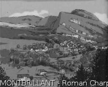
Montbrillant - Roman Charpentier History & HeritageMontbrillant
During the 19th century, valleys were transformed into real “industrial boulevards” in which modest workshops and major factories can be found and where several types of production either cohabited or succeeded one another. Fulling mills, grain mills, sawmills, wood turning factories, diamond factories, etc.: several hamlets underwent industrial growth and changes in names, sometimes resulting from the rapid change in rural differences. Thus, the hamlet “la Patinerie”, in the municipality of Villard-Saint-Sauveur, became “Montbrillant” in 1885 to reflect the new diamond industry that had developed in the High-Jura.
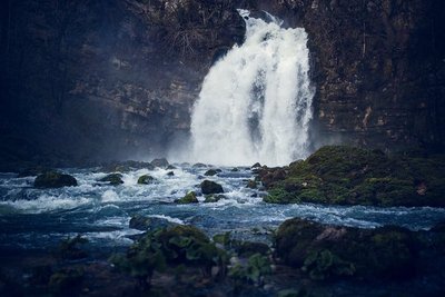
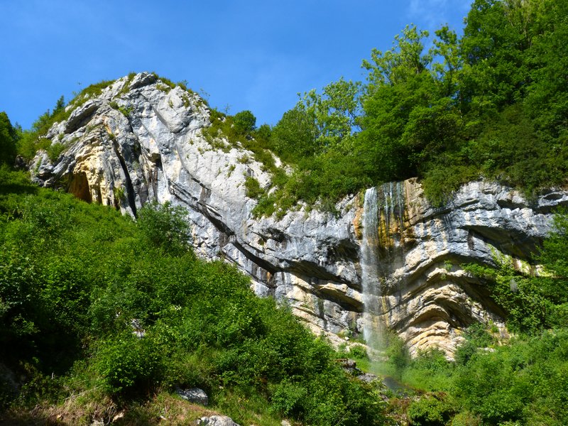
Cascades du Flumen - WaterfallsThe Flumen Waterfall
The Flumen - which means “river” in latin - is actually nothing like a river. With its impetuous torrent, which can be quite impressive during periods of heavy rainfall, it is fed by the runoff water from the Lamoura lake and the Hautes-Combes. The Flumen waterfalls spurt out into a dark and wild cirque.
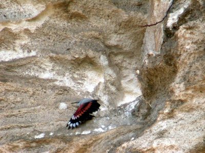
L'oiseau papillon - Fabrice Croset FaunaThe wallcreeper
Dark grey in colour, the wallcreeper is almost invisible on the rocks when immobile. Its flaming red wings bring colour to the cliff when it spreads them to flit against the rocks, giving it the name “wallcreeper”. When hunting for insects and spiders that it catches in cracks in the walls using its thin curved beak, this bird tirelessly jumps, crawls and flutters around the cliffs. But in the summer, you won’t see it here, as it has already retreated up into the mountains. Your only chance of seeing this bird is between autumn and spring.
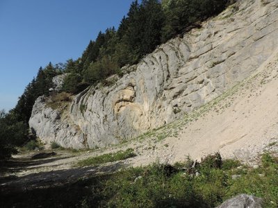
Belvédère de la Roche Blanche - Gilles Prost - PNRHJ ViewpointBelvedere of the Roche Blanche
The view from this belvedere, which can be seen from Sur les Grès, overlooks the Flumen wind gap, cut into the Sur les Grès anticline. By digging deep gorges at the same time folding occurs, over tens of millions of years, the river has created a perfect cut into the many geological layers that are well visible on the Sur les Grès anticline upfold and shows the very core of the Jura’s folds.
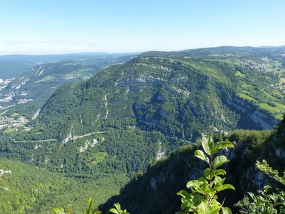
Mise en pli bigoudi ou champignon ? - Gilles Prost - PNRHJ GeologyCurved fold or fungus?
I'ts difficult not to notice this peculiar fold, almost folded in on itself. It is in fact a “secondary” or disharmonic fold, arising due to the overlapping of the Molunes anticline over the neighbouring Septmoncel valley syncline. This is a remarkable example of hard rock’s ability to bend over time, and even over millions of years, under considerable pressure.
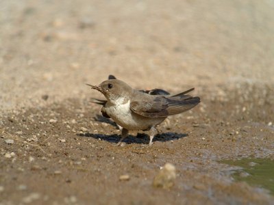
L'Hirondelle de rochers - Fabrice Croset FaunaThe Eurasian crag martin
This bird from the swallow family nests in the cliffs, sheltered from the overhangs. But in the Flumen valley, some couples live in the tunnel of the “route des lacets”, also called “Roche percée” (the drilled rock). Near Morez, the crag martin has even used the famous archways of the viaducts as a home.
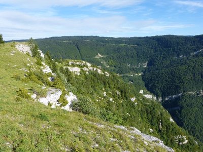
Point de vue de Sur les Grès - Gilles Prost - PNRHJ ViewpointViewpoint over Sur les Grès
This viewpoint overlooks the landscapes in the classified site of the Gorges of the Flumen. From the summit, you may see a peregrine falcon or a golden eagle flying graciously overhead.
The golden eagle builds one or several nests in steep areas, on the side of a cliff or in a tree on a steep slope. At the end of the winter, it may put on impressive shows in the air. In the summer, it is more often seen tirelessly scouring for food.
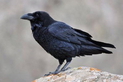
Le grand Corbeau - Fabrice Croset FaunaThe common raven
The common raven is the largest passerine bird in Europe. It is well-known as an inhabitant of the Tower of London where their disappearance would mean misfortune. In the Jura, this bird can mainly be found on the cliffs, near the peregrine falcons. Its call can be heard from as early as February.
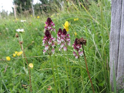
L'Orchis brulée - Julien Barlet - PNRHJ FloraThe burnt-tip orchid
Calcareous grasslands are home to many species of plants, the most famous of which are orchids. These flowers demonstrate their significant ability to adapt. Most are pollinated by insects, when very few even produce nectar! To ensure its pollination, the burnt-tip orchid has adapted by imitating other nectar-producing plants. Their inner petals are adorned with colourful designs that converge towards the centre of the flower and tell the insect where to land. An actual landing strip! But the insect leaves empty handed as the flower doesn’t have any nectar to give. Still, it makes the most of the insect’s visit to cover it with pollen, which it will then take to another flower.
Description
From the REPLAN, the circuit (yellow waymarking) heads down “Chemin des Moines” (The Monks’ path) to the D 436 in MONTBRILLAND.
Head up the road following along the right border and head past La Roche percée for around 20 m.
A stony trail descends to the right and crosses over a few screes. At Bas des Grès, continue right until you come to the Flumen and use the walkway next to its concrete penstock to cross it.
> Flumen waterfalls, 15 mins out-and-back. Head up the path to your left; Head past a dam and continue until you come to the upsurges. Surrounded by high waters, head up the stony path to your right and then turn left (copse) to reach the waterfalls.
On returning from the waterfall, the path heads down the left embankment to the Electricity factory.
The steep trail to your left heads through Sous la Riote and up to the ridge on a tricky ascent (700 m difference in level), before exiting onto the LA ROCHE BLANCHE BELVEDERE. A grassy trail heads due south and, following along the fence, meets up with a road. Follow the road to your left for 500 m heading to the houses in La Cernaise.
Between two buildings, turn left and join up with the D 25 in CHAMPIGNON DE LA CERNAISE. A forest trail which is muddy in places heads down to your left towards Les Moulins. Head 150 m down the “route des lacets de Septmoncel”, before turning left and joining up with a lesser bend called “le virage des Savants” (the Wise men’s bend).
> The viewpoint from Saut du Chien and the MOULIN D’AVAL WATERFALL can be accessed in a few minutes via the road to your left.
From the “Virage des Savants”, climb the bank opposite you and cut through the bends twice, heading up to the CHAPEAU DE GENDARME.
> The foot of the Chapeau de Gendarme can be accessed within 10 mins there-and-back to your right by following a trail parallel to the road.
When you return, a steep trail heads through the pastures and follows along the ridge before reaching SUR LES GRES. Return to your point of departure via a path that heads down to the right through a dry grassland.
- Departure : Le Replan Septmoncel
- Arrival : Le Replan Septmoncel
- Towns crossed : Septmoncel Les Molunes and Villard-Saint-Sauveur
Forecast
Altimetric profile
Recommandations
Take care along the cliffs before Roche Blanche and in Sur les Grès; on the roadside and at the crossings between Montbrillant and La Roche Percée; as well as between Les moulins and the Chapeau de Gendarme. The trail to access the Flumen waterfalls can be slippery during humid weather.
This trail passes through pastures with livestock and forest paths. To respect the owners and farmers granting you passage, and for the security of livestock and wild fauna, we ask that you remain on the waymarked paths. Use the adapted passageways to get across fencing and be sure to close gateways behind you. Please keep your dog on a lead if you have one.
Wild flowers are beautiful, they may be rare and protected and often wilt quickly. Do not pick them! They will delight the next hikers.
In case of forest works (felling, skidding, etc.), for your safety, know when to stop and turn around.
Information desks

Tourist information centre - Haut-Jura Saint-Claude
3 place de l'Abbaye, 39200 Saint-Claude
Transport
To visit and get about in the High-Jura, visit www.reshaut-jura.fr, the eco-mobility portal listing all means of transport within the Park.
Access and parking
10 km east of Saint-Claude via the D 436 until Septmoncel. In the heart of the village, at “place Dalloz”, head up to the Replan to your left via “rue Centrale” and then “rue du Mont”.
Parking :
Report a problem or an error
If you have found an error on this page or if you have noticed any problems during your hike, please report them to us here: