Hike around Fyète
10 points of interest
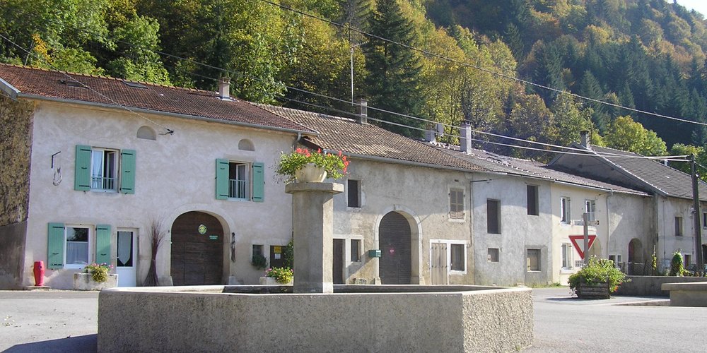
Coulouvre - Gilles Prost - PNRHJ History & HeritageCoulouvre
This place owes its name to the many vipers (“couleuvres” in French) that inhabit the now dry marshland close to the hamlet of Coulouvre. Three wood turning companies continue the tradition of manufacturing animal call instruments out of boxwood using traditional methods.
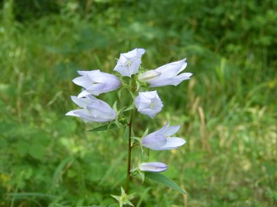
La Campanule fausse raiponce - Gilles Prost - PNRHJ FloraThe creeping bellflower
Easily to spot, this plant is quite common in woods and in meadows, ranging from 40 to 80 centimetres in height, with pale blue to violet bell-shaped flowers. In the summer, you will find it on the very first steep hills heading up to the Fyète woods. This plant was once picked for its fleshy root, which can be eaten cooked or raw like carrots.
On the edge of paths, you will also find raspberry and blackberry bushes surrounded by pines having naturally regenerated, searching for sunlight to grow their fruit and become engorged with sugar.
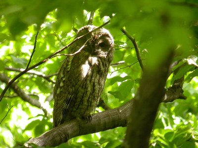
La Chouette hulotte - Fabrice Croset FaunaThe tawny owl
Its reputation as the most common nocturnal bird of prey in France does not make the tawny owl any easier to spot and it is often seen at a quick glance flying over the road, lit-up by a car’s headlights. However, its hoot has been heard by all, starting with an easily-recognised short hoot, followed by silence and then a longer hoot, which is often found in nocturnal cinematic scenes. Its deep black eyes set it apart from nearly all other nocturnal birds of prey.
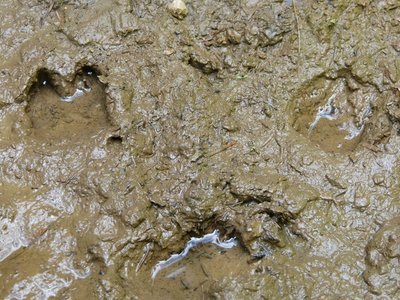
Traces de sanglier - Gilles Prost - PNRHJ FaunaA few forest guests
The path that heads along the ridge of the Fyète forest is scattered with a few small muddy ponds, even in mid-summer. You will easily be able to make out some of the tracks left behind by the animals that live here such as the wild boar, the stag or the deer. Although boar and deer are species that are present all over the Jura massif, the stag is more isolated and its numbers are currently growing in the High-Jura.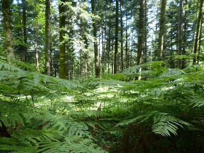
Le télégraphe optique - History & HeritageThe optical telegraph
The very serious dictionary of the municipalities of the Jura, written by A. Rousset (1854), states that the summit of the Fyète forest, reaching 898 meters in altitude, was equipped in 1831 with a semaphore telegraph for the purposes of drawing-up military maps. This semaphore system appears to have been a Chappe system, named after the famous inventor of the optical telegraph, an ancestor to the electric telegraph system, and which was already able to send messages at close to 700 kilometres an hour, but only during good weather!
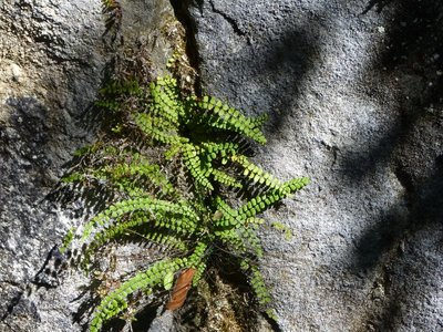
Le puits du Fyète - Gilles Prost - PNRHJ GeologyThe Fyète well
Well-protected by a railing, this smooth-sided abyss is comprised of one single 33-metre-deep well. Cut into the vertical rocks, this well is the result of the collapse or dissolution of limestone layers by the flow of water. Several terms are used to refer to these spectacular Karstic phenomena: abyss, chasm, well... Notice the black spleenwort fern plants that grow in the crevices of the walls.
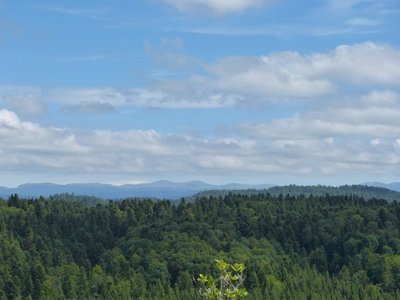
Point de vue sur la Haute-Chaîne du Jura - Gilles Prost - PNRHJ ViewpointViewpoint over the High-Jura mountain range
From this modest promontory along the Fyète ridge, the forest fills the space like a green sea and draws the eye up to the highest summits of the High-Jura mountain range. From left to right you will see the Dole massif (1,680 mm) in Switzerland, topped by its radar dome, the Massacre massif and its flowing ski slopes, the Grand Montrond, the Colomby de Gex alongside its twin, the Montoisey and lastly the slightly-wooded massif of the Crêt de la Neige (1,719 m), the highest point of the Jura mountains.
During fair and dry weather, you may see a tiny white triangle in the dip of the La Faucille Pass. This triangle is the Mont Blanc.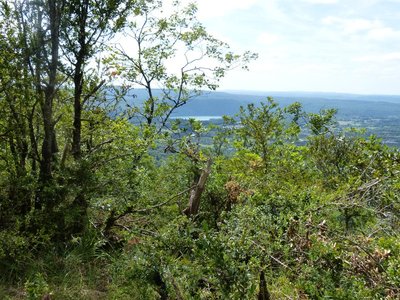
Point de vue sur la vallée de l'Ain - Gilles Prost - PNRHJ ViewpointViewpoint over the Ain valley
From the rocky edge overlooking the hamlet of Coulouvre, your eyes are drawn to the blue waters of the Vouglans lake at the bottom of the Ain valley. In the distance, you can make out the wavy lines of the Petite Montagne and the first plateau overlooking the Lons-le-Saunier basin.
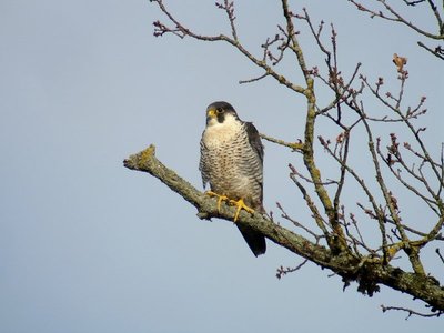
Le Faucon pèlerin - Fabrice Croset FaunaThe Peregrine Falcon
The peregrine falcon was declared a protected species in 1965. In the Park, a biotope protection order ensures that it is left alone in reproductive areas. This bird of prey is monogamous (only has one partner) and leads a mainly sedentary lifestyle. Fifty couples currently inhabit the cliffs in the High-Jura Regional Natural Park.
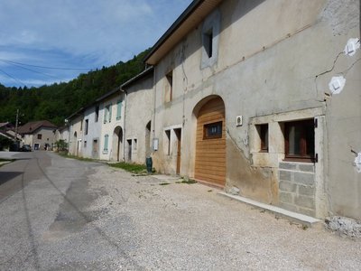
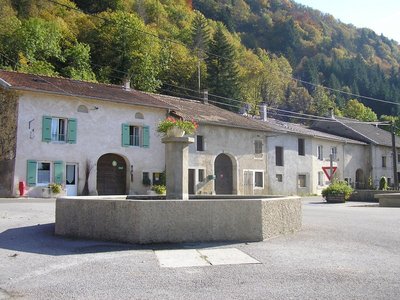
Coulouvre, hameau de Crenans - History & HeritageCoulouvre, the hamlet of Crenans
In the village, buildings are organised in “spans”, mainly due to constraints relating to adjoining houses. Thus, each span tied the building to a specific purpose: stables, barns or housing. Wind-break walls (or the advanced position of gable walls, on the main facade) are characteristic of rural houses in the High-Jura. Balconies, which provide a gallery on the main facade and serve to dry wood and crops, are fairly common architectural elements in this area. Rural buildings also demonstrate the strong relation between agricultural activities and craft activities.
Description
From the Fountain square, the trail takes the road northbound (yellow waymarking), until it exits the hamlet at Côte de Guy.
The road gradually heads up to the right, through a forest, until its reaches the ridge. Branch off to the right and follow a path until you come to a first opening to the east (viewpoint onto the Roche d’Antre)
Continue for around 500m to access FYETE WELL.
The well can be reached within 5 mins there and back. Descend to the left and access to edge of the well.
Back at “chemin de crête”, head south (viewpoint to the west over the villages of Coulouvre and, further along, Charchilla). In the background, locate the furrow in the Ain valley occupied by the Lake of Vouglans). Head past the viewpoint and descend to la Baume.
Turn right to descend on a rocky trail that, after two zigzags, comes to the hamlet of Coulouvre. Take the D 296 to the right for a few meters to reach your starting point.
- Departure : Coulouvre, Place de la Fontaine (the fountain square)
- Arrival : Coulouvre, Place de la Fontaine (the fountain square)
- Towns crossed : Crenans
Forecast
Recommandations
Be careful along the edge of the Fyète well.
This trail uses forest paths. To respect the owners and farmers granting you passage, and for the security of wild fauna, we ask that you remain on the waymarked paths.
Please keep your dog on a lead if you have one.
Wild flowers are beautiful, they may be rare and protected and often wilt quickly. Do not pick them! They will delight the next hikers.
In case of forest works (felling, skidding, etc.), for your safety, know when to stop and turn around.
Information desks

Tourist information centre - Jura Sud
3 bis rue du Murgin, 39260 Moirans-en-Montagne
Transport
Access and parking
Parking :
Report a problem or an error
If you have found an error on this page or if you have noticed any problems during your hike, please report them to us here: