The Path to the Castle
4 points of interest
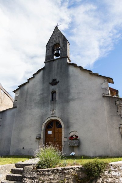
La chapelle Saint-Etienne - Nina Verjus - PNRHJ History & HeritageThe Saint-Etienne chapel
After Franche-Comté’s defeat, and its inclusion in the Kingdom of France, the local lord and main advocate for Spanish dominance in Franche-Comté, Jacques-Antoine de Maisod, decided to rebuild the Maisod chapel in 1693. This “late Romanesque” chapel may have succeeded the first chapel, dated 1184, and part of this previous chapel’s materials may also have been used to rebuild the current chapel (P. Lacroix, 1981). It bears a coat of arms resembling an alliance of the Guigue de Champvans family and the inscription “Concuccus Resurgo” (Beat down, I get back up).
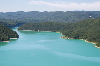
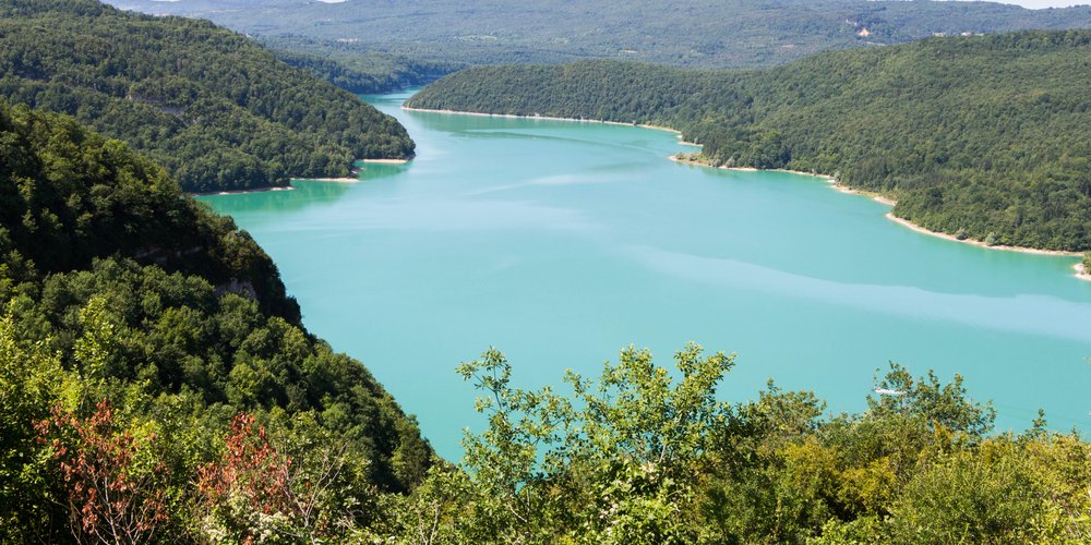
Belvédère de Sur la Fratte - Nina Verjus - PNRHJ ViewpointBelvedere of Sur la Fratte
Made by man in the 1960s to feed a power plant, the ribbon of turquoise water from the Vouglans lake, winds 35 kilometres through the Ain valley from Pont-de-Poitte to the hamlet of Vouglans, in Lect. Its semi-circular dam which is 103 metres tall holds back 600 million cubic metres of water. Every year, it provides electricity to 130,000 inhabitants and, as such, is the second largest hydro-electric plant in France.
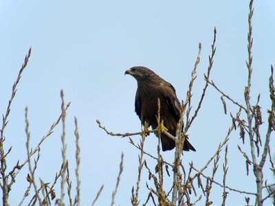
Le Milan noir - Fabrice Croset FaunaThe black kite
With a love of lakes and humid environments, it isn’t rare to see this bird of prey’s dark silhouette over the water. A migratory bird, it travels to France in March and returns to Africa for the winter in mid-August or September. Very much a scavenger, it often snatches up dead fish from the surface of the water. It also flies over meadows during hay-cutting periods in search of prey made vulnerable by the short grass.
Habitats et corridors écologiques : les haies - Fabrice Croset Natural environmentsHabitats and ecological corridors: hedges
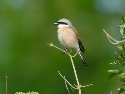
The diversity of the shrub species that make up hedges, their height and their varying density attract a diverse range of insect, bird and reptile species, and even some mammals who favour this dense and protective environments. In the summer, you may be lucky enough to see a red-backed shrike perched on a high branch searching for prey, a mimetic praying mantis camouflaged by the leaves, or a green whip snake coiled up under bush formations. Hedges provide a variety of micro-habitats, which allow many species to travel and are therefore real biological reservoirs and corridors that should be preserved.
Description
From MAISOD, the trail follows (yellow waymarking) rue Pont-de-la-Pyle to the Chapel before descending to To the well.
Ascend the rue du Château to your left (low wall with half-moon stones) and follow a farm path (on the left, a reservoir in cut stone used today for fire control). The trail heads into a forest planted with pine trees and comes to a rocky boundary. Quickly descend to Sur la Fratte, cutting through the boxwood.
The BELVEDERE OF SUR LA FRATTE can be reached within 10 minutes there and back to your right (yellow and red waymarking and then yellow waymarking). Head to a forest platform and follow a wide path to your left that descends to the viewpoint over the lake.
On returning to Sur la Fratte, the well-shaded trail heads south (yellow and red waymarking) (boxwood, oak trees, fir trees, white birch trees). After the water treatment plant, the trail crosses a wide path and descends to the edge of the beach (picnic tables). Follow this “coastal” trail to the left, and then take the road above the port. Head past a holiday village and take the road to reach La Pierre Fendue.
Head up the steep path to your left (yellow waymarking) towards a campsite. Head past a forest clearing and exit onto the route du Mont du Cerf at the Trélachaume campsite.
Follow this road to the left for 50 meters, and then go right twice towards Maisod.
Take the trail through the forest to your left, on the right of a football pitch. At the first houses in Maisod, take rue des Cyclamens to the left, then head down rue du Château until you come to the foot of the Chapel.
Head back to the MAISOD town hall parking lot the same way you came.
- Departure : Maisod town hall
- Arrival : Maisod town hall
- Towns crossed : Maisod
Forecast
Recommandations
Be careful of the rocky edge when descending to Sur la Fratte.
This trail passes through private property pastures with livestock and forest paths. To respect the owners and farmers granting you passage, and for the security of livestock and wild fauna, we ask that you remain on the waymarked paths. Use the adapted passageways to get across fencing and be sure to close gateways behind you.
Please keep your dog on a lead if you have one.
Wild flowers are beautiful, they may be rare and protected and often wilt quickly. Do not pick them! They will delight the next hikers.
In case of forest works (felling, skidding, etc.), for your safety, know when to stop and turn around.Information desks

Tourist information centre - Jura Sud
3 bis rue du Murgin, 39260 Moirans-en-Montagne
Transport
Access and parking
Parking :
Report a problem or an error
If you have found an error on this page or if you have noticed any problems during your hike, please report them to us here: