Chaux Mourant Forest
In a bucolic environment, this trail will take you on a journey through forests, combes and clearings. Along this charming mountain trail, you will walk in the footsteps of the "gabelous" before discovering the Roche Devant belvedere and its view over the vast pastures that punctuate the thick tapestry of coniferous trees.
*"Gabelous" was the name used to refer to customs officers by smugglers who once traded with Switzerland in their own unique way.
4 points of interest
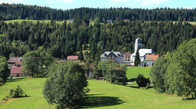
Egles de Bellefontaine - Gérard Gerbod History & HeritageBellefontaine
The story behind this village’s name dates back to the 1630s. At the time, the Franche-Comté region was still independent and was victim of the ravage caused by the passing of German and French hordes. Inhabitants from nearby villages therefore took to travelling up to this hilltop village in search of uncontaminated water sources. Belle-fontaine was thus named to mean “bonne fontaine” (good fountain), “bonne eau” (good water).
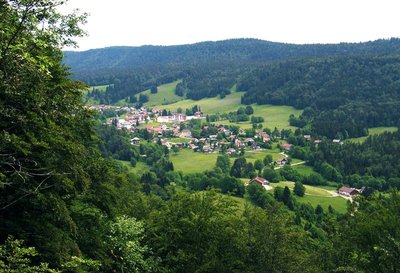
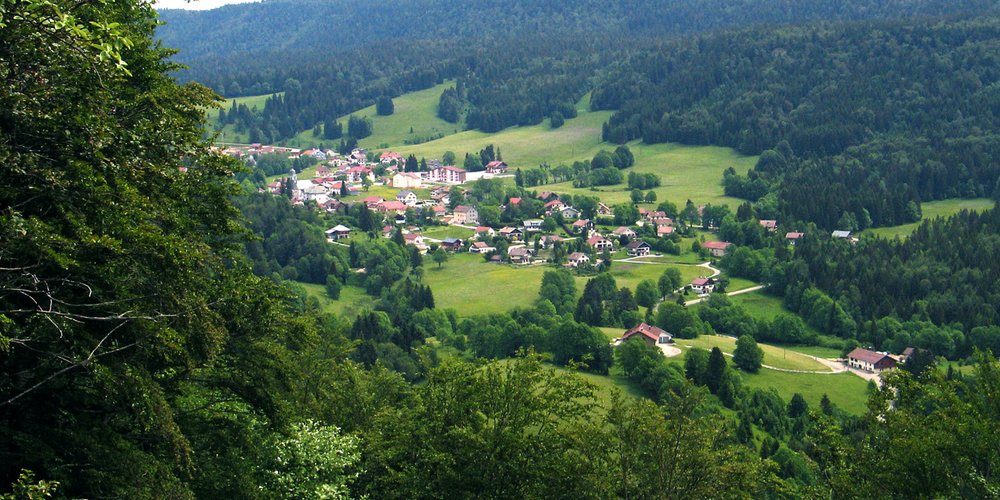
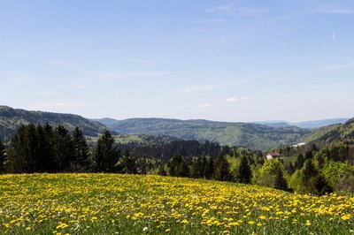
Roche de Devant - Gérard Gerbod ViewpointViewpoint from Roche Devant
“The Roche Devant belvedere offers an almost southern atmosphere with its rocky outcrops, dry grasslands and prolonged exposure to sunlight... From it, visitors are offered a view over the plateau and the forest of Risoux just opposite, as well as a horizontal view of the valley of Bellefontaine extending from the village to the Morez wind gap, passing through the gorges of l’Évalude. The mosaic of meadows and wooded areas that makes up the valley appears to be progressively swallowed up by the forest rolling down the Risoux. This impression is particularly noticeable south of the village of Bellefontaine.” F. Wattellier
Point de vue du castel des buses - Nina Verjus - PNRHJ ViewpointViewpoint from Castel des Buses
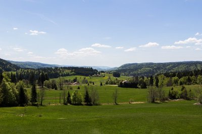
This viewpoint offers a wide 180° panorama over the combe of the Morbier marshlands, framed to the east (on your left) by the Chaux-Mourant woods and to the west (on your right) by the Mont Noir forest. This landscape is known for its rural atmosphere and its dispersed habitat.
Point de vue du sacre cœur - Nina Verjus - PNRHJ ViewpointViewpoint from Sacré Coeur
“Located on the rounded top of one of the small hills formed by morainic deposits, the statue of the Virgin Mary overlooks the wave of grasslands and forests rolling down towards the Morez wind gap, to the south-west. Here, visitors can get up-close and personal with this agricultural landscape, surrounded by pastures and trees”. F. Wattellier
Description
Starting at the TOURIST INFORMATION CHALET, this trail follows the road (yellow waymarking) towards the church, turning right after the municipal hall (white and red waymarking) before immediately heading left on a gravel path along the cemetery and reaching the Le Clos signpost.
A small road ascends to the left (yellow and red waymarking) until it reaches Chaux Mourant.
Then follow "route des près" to the left until you reach the last houses. Pass between the buildings and gradually progress through the forest to reach Chaux Mourant Forest, The Four Paths and ROCHE DEVANT.
The viewpoint is approximately 10 meters to your left.
At the ROCHE DEVANT signpost, the path to your right (yellow waymarking) will lead you to Les Chaumelles and then head left. Follow the fall line to reach Castel-des-Buses.
To the right, the bordering path (meadows and plantations) will take you towards Pré Jean-Guy. Head past Chalet Peccaud and continue on until you reach a crossroads named LES VIGNES at the heart of the High Morbier Marsh Combe and its dispersed habitat.
Continue through the meadow and follow a small road to your right for approximately 100 m, then take a large dirt road to reach Les Violes.
A forest path heads up and then becomes hilly to the south. It cuts through a clearing before exiting the forest and joining up with a small paved road at the Sous le Chalet signpost. Turn right towards SACRÉ CŒUR.
The Sacré Cœur viewpoint can be accessed within 2 minutes.
The road heads downwards in a wide bend at the Chaux Mourant crossroads, from here you can return to the village of Bellefontaine the same way you came.
- Departure : Bellefontaine
- Arrival : Bellefontaine
- Towns crossed : Bellefontaine and Morbier
Forecast
Altimetric profile
Sensitive areas
Western capercaillie
- Impacted practices:
- , Land-based
- Sensitivity periods:
- JanFebMarAprMayJunDec
- Contact:
Recommandations
Be careful around the Roche Devant viewpoint.
This trail passes through pastures with livestock and forest paths. To respect the owners and farmers granting you passage, and for the security of livestock and wild fauna, we ask that you remain on the waymarked paths. Use the adapted passageways to get across fencing and be sure to close gateways behind you.
Please keep your dog on a lead if you have one.
Wild flowers are beautiful, they may be rare and protected and often wilt quickly. Do not pick them! They will delight the next hikers.
In case of forest works (felling, skidding, etc.), for your safety, know when to stop and turn around.
Information desks

Tourist information centre - Haut-Jura Morez
Place Jean Jaurès, 39403 Morez
Transport
To visit and get about in the High-Jura, visit www.reshaut-jura.fr, the eco-mobility portal listing all means of transport within the Park.
Access and parking
8 km northeast of Morez via the N5, followed by the D 18.
Parking :
Report a problem or an error
If you have found an error on this page or if you have noticed any problems during your hike, please report them to us here: